190 m away
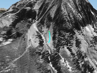
Total Recall

Total Recall can be a hidden West Side pow stash through steep trees with some small cliffs at the bottom.
Severe Freeride Skiing
- Distance
- 347 m
- Ascent
- 0 m
- Descent
- 218 m
A bump run through the aspen trees
Freeride Skiing Moderate

This is a popular freeride skiing route which is generally considered to be moderate. It's remote, it features unknown exposure and is typically done in an unknown time of year. From a low point of 3.1 km to the maximum altitude of 3.2 km, the route covers 521 m, 0 vertical metres of ascent and 107 vertical metres of descent.
The Luge is a bump run through the aspen trees that acts as a traverse from Peel, Flatiron, and Banana to Aspen Park Road under Forest.
Moderate
Slopes become slightly steeper at around 25-30 degrees.

Away from help but easily accessed.
190 m away
Total Recall can be a hidden West Side pow stash through steep trees with some small cliffs at the bottom.
Severe Freeride Skiing
209 m away

A traverse from the West Side runs back to Aspen Park Road that saves you heading down Hockey Rink to Banana Exit.
Moderate Freeride Skiing
234 m away
The bottom of Funnel ends in the Pygmy Spear Garden, a lower angle powder field with bumps, small trees, and bushes.
Moderate Freeride Skiing
312 m away

Hidden Chutes are steep tree chutes off of Sunset Ridge in Funnel.
Severe Freeride Skiing
322 m away

Predator offers steep trees and fun skiing after a storm off of Sunset Ridge.
Severe Freeride Skiing
346 m away

Sunset Ridge is a classic spring line in Crested Butte on the western boundary of the resort.
Difficult Freeride Skiing
448 m away

Chiquita holds soft snow hours after the powder frenzy on the skier's left side of Banana.
Difficult Freeride Skiing
468 m away

A bump run originally cut for the Old Silver Queen Gondola.
Moderate Freeride Skiing
498 m away

Well pitched tree section in between Crystal and International.
Moderate Freeride Skiing
540 m away

House Rock and Weather Station are powder stashes off of the Silver Queen that put you into Upper Forest.
Difficult Freeride Skiing
80 routes · Freeride Skiing