2.6 km away
Lake Creek Trails

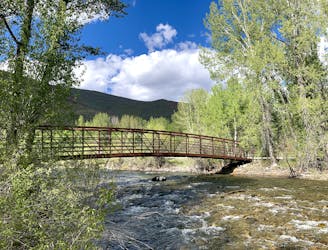
A stroll along the Big Wood River, through forest and fields that gorgeous in all seasons.
Easy Hiking
- Distance
- 2.2 km
- Ascent
- 17 m
- Descent
- 17 m
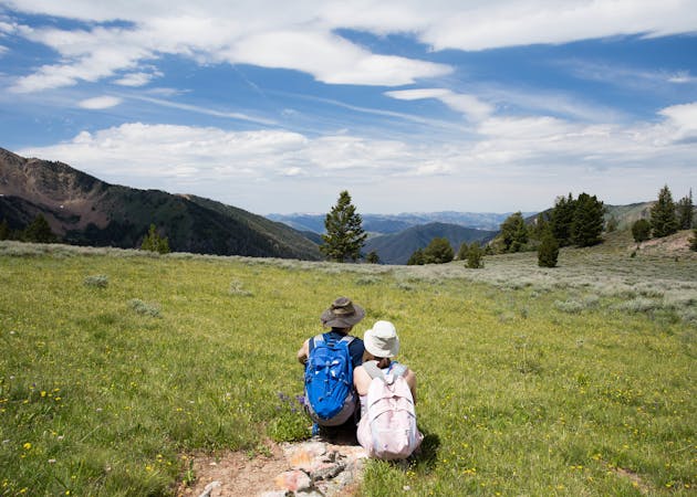
A great workout with mountain vistas and summer wildflowers.
Hiking Difficult

Just up the road from Ketchum is this somewhat hidden gem of a trail, on the edge of the national forest. The length and distance make it perfect for an aerobic morning or evening jaunt. With quick elevation gain, it’s quite the workout and the views are tremendous. The loop includes a steep canyon with sparse forest, then a rolling ridge walk in sage grassland, overlooking the valley and mountains beyond. It’s especially scenic in June, when wildflowers paint the slopes, or in October when the leaves change.
This hike is best for cooler days because it's quite exposed. If it's warm, you’ll want to go counterclockwise, beginning with the ascent of the main canyon. It can still be sunny, but gives more shade than the rest of the trail. A gradual incline makes the first mile, then a steep set of switchbacks gain the ridge. Luckily, the switchbacks are shaded in a side canyon by a patch of pines.
Once on the ridge, you’ll find the panorama you anticipated, and it just gets better as the trail meanders downhill. Ketchum and the Big Wood River lie in the valley below, with Bald Mountain’s ski runs as a backdrop, plus countless other mountains forming the horizon. Enjoy the views and take it slow, because the final descent to the trailhead is rather steep and rocky.
The trail is reached by a dirt road just beyond the Lake Creek subdivision. The road is fine for most cars, but the parking area is small and rough in places. If you can’t find a suitable spot there, you may find a pullout elsewhere along the road and walk to the trailhead.
Sources: https://www.visitsunvalley.com/summer/hiking-in-sun-valley-idaho-a-summer-guide/ https://summertrailink.bcrd.org/taylorcanyontrail324.php
Difficult
Hiking trails where obstacles such as rocks or roots are prevalent. Some obstacles can require care to step over or around. At times, the trail can be worn and eroded. The grade of the trail is generally quite steep, and can often lead to strenuous hiking.

The trail contains some obstacles such as outcroppings and rock which could cause injury.
Away from help but easily accessed.
2.6 km away
A stroll along the Big Wood River, through forest and fields that gorgeous in all seasons.
Easy Hiking
3.5 km away
A local favorite trail with nicely varied scenery and elevated views.
Moderate Hiking
4.2 km away
Hilltop views in a steep hike close to town, and one of the world's oldest chairlifts.
Difficult Hiking
5.5 km away

A quick hike near Sun Valley Lodge, with nice views of the resort and the town.
Easy Hiking
5.5 km away

A local go-to loop in the foothills, good for hiking shortly after the snow melts.
Easy Hiking
7 routes · Hiking
5 routes · Alpine Climbing · Hiking
13 routes · Alpine Climbing · Mountain Biking · Gravel Biking · Hiking · Road Biking · Sailing · Trail Running