4.9 km away
The Presidential Traverse
One of the greatest hikes in White Mountains of New Hampshire.
Severe Hiking
- Distance
- 32 km
- Ascent
- 2.8 km
- Descent
- 2.6 km
White Mountains National Park
Hiking Difficult

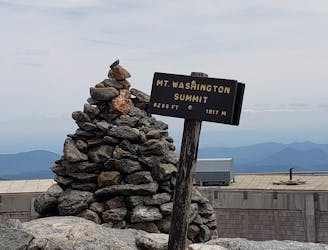
Today and tomorrow the hikes are completely above the treeline, and the endless views up here are excellent. However, you’re exposed to the Presidential Range’s sometimes catastrophic weather and are well-advised to familiarize yourself with possible routes to safety below the treeline. The base itinerary is 5 hours of hiking over rocky, undulating terrain totaling 2,343 feet (714 meters) of ascent, but there are multiple possible 4,000-foot summits to expand this itinerary. Of note are Mount Adams, Mount Jefferson, Mount Clay, and, of course, Mount Washington. Time your trek right and you’ll be able to enjoy blooming alpine flowers on Mount Washington’s eastern slope if you’re not blown away by gale-force winds.
www.pygmy-elephant.com
Difficult
Hiking trails where obstacles such as rocks or roots are prevalent. Some obstacles can require care to step over or around. At times, the trail can be worn and eroded. The grade of the trail is generally quite steep, and can often lead to strenuous hiking.

The trail contains some obstacles such as outcroppings and rock which could cause injury.
Away from help but easily accessed.
4.9 km away
One of the greatest hikes in White Mountains of New Hampshire.
Severe Hiking
8.2 km away
A beautiful segment of the AT, summiting the final 4,000-footers in New Hampshire before heading into Maine.
Severe Hiking

58 routes · Hiking

10 routes · Hiking