23 m away
Mount Marcy via Elk Lake
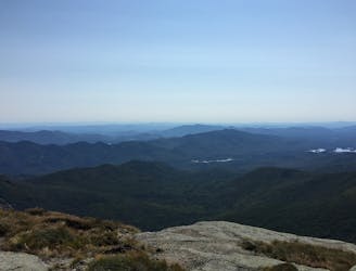
A lengthy and lesser-traveled approach to Mount Marcy.
Difficult Hiking
- Distance
- 34 km
- Ascent
- 1.6 km
- Descent
- 1.6 km
An epic loop through the Adirondack High peaks
Hiking Severe

OVERVIEW: A route which follows steep climbs up several Adirondack high Peaks: namely Mount Marcy, the Saddleback cliffs, and the Gothic cables. This trail also links together many different trails (including the famous Great Range traverse) into a loop hike with several camping options.
DETAILED: Starting at the Elk Lake trailhead, follow a lengthy and remote approach to Mount Marcy, passing over the Gorgeous Bores-Colvin range, and going through a few swamps and bogs. Then about 9 miles in, you'll find a primitive campsite at the trail junction with the Bartlett Ridge Trail, just below the climb up Mount Marcy, which also has a stream.
From there the summit of Mount Marcy is only 2 miles away however, the last 500 feet of the ascent are above treeline, and like most of the above treeline sections of this trail, is steep and treacherous when wet. After reaching the summit of Mount Marcy and celebrating your achievement with the throngs of other Avid peak baggers, descend, and in 2 miles you'll reach 2 more primitive camping options along side a stream. These are great alternatives to spend your first night if you're able to do the 12 miles in one day.
From the 2 campsites walk 2 miles and you'll be at lake Colden, which also has camping options - albeit more crowded. From Lake Colden you'll have a steep 2 mile ascent up Mount Colden at 4,712 feet, followed by a more mellow descent to another lake-front camping option 1 1/2 miles below the summit. From there you have a mellower 5 miles to SnowBird campsite, with spur trails leading to both Mount Marcy and to Mount Haystack.
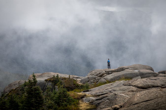
From SnowBird campsite you have an epic traverse, following the Great Range Traverse trail, but be prepared for a hard day of Class 3 and 4 ascents, exposed Bluffs, and Gorgeous views. From the SnowBird campsite it's a 6 mile steep, streneus and rewarding hike to the next primitive campsite with steep ascents up the SaddleBack cliffs, and the Gothic Cables (both above treeline, and treacherous when wet). Alternatively, if you wish to continue past the campsite, you're looking at an extra 7 miles, with a steep descent to a road, followed by a steep ascent and a forested mellower ridgeline to the next primitive campsite on the shores of 2 small ponds.
Past this campsite you'll encounter a steady 1.25 mile climb up to Mount Colvin, followed by an up and down 3.5 mile ridge traverse with a steep climb up Blake Peak, and multiple lookout points. After you finish the high ridgeline you have a steady 7 mile descent and return back to your car on the same route you took to summit Mount Marcy.
Severe
Hiking challenging trails where simple scrambling, with the occasional use of the hands, is a distinct possibility. The trails are often filled with all manner of obstacles both small and large, and the hills are very steep. Obstacles and challenges are often unexpected and can be unpredictable.

Some trail sections have exposed ledges or steep ascents/descents where falling could cause serious injury.
Little chance of being seen or helped in case of an accident.
23 m away
A lengthy and lesser-traveled approach to Mount Marcy.
Difficult Hiking
9 routes · Hiking