5.5 km away
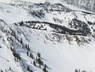
Scotty's Bowl

A nice long powder stash
Difficult Freeride Skiing
- Distance
- 1.9 km
- Ascent
- 6 m
- Descent
- 752 m
this face has a rocky, narrow start, then opens up into a nice wide face, with a small cliff band to finish it off.
Freeride Skiing Severe

This is a popular freeride skiing route which is generally considered to be severe. It's very remote, it features medium exposure (e2) and is typically done between February and June. From a low point of 2.9 km to the maximum altitude of 3.4 km, the route covers 849 m, 0 vertical metres of ascent and 575 vertical metres of descent.
this run starts with a pitch down the steep ridgeline, then drops through a chute and over a small cliff band. it then opens up a bit before another cliff band. after that, it chills out a bit, with a wide open apron. there is one more cliff, then its over.
Severe
Steep skiing at 38-45 degrees. This requires very good technique and the risk of falling has serious consequences.

As well as the slope itself, there are some obstacles (such as rock outcrops) which could aggravate injury.

Little chance of being seen or helped in case of an accident.
5.5 km away
A nice long powder stash
Difficult Freeride Skiing
5.7 km away

Steep technical skiing in the Carbonate Cliffs.
Severe Freeride Skiing
5.8 km away

A secret bowl with trees near the top
Moderate Freeride Skiing
6.2 km away

A steep slot though the trees
Difficult Freeride Skiing
6.2 km away

Very steep technical tree skiing
Difficult Freeride Skiing
6.4 km away

A steep, wide open chute
Difficult Freeride Skiing
6.6 km away

Secret gate that takes you just other side of rope line
Difficult Freeride Skiing
6.6 km away

A technical Double Cliff
Extreme Freeride Skiing
6.7 km away

Steep technical skiing in the Forbidden Zone.
Extreme Freeride Skiing
6.7 km away
A short, tight straight line
Extreme Freeride Skiing