4.9 km away
God's Lawnmower

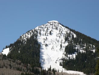
This is the huge avalanche path that's visible from the road on the N slope of Kessler Peak.
Difficult Ski Touring
- Distance
- 2 km
- Ascent
- 2 m
- Descent
- 946 m

Davis Gulch is the large powder slope that runs off of Gobblers Knob one of the largest and most prominent peaks on the Big Cottonwood/Millcreek divide.
Ski Touring Moderate

The Davis Gulch is a Wasatch classic with a wide, open slope at a consistent pitch in the upper thirty degree range. To access, park at the Porter Fork trailhead in upper Millcreek Canyon. Head through the gate and up the road through the cabins and enter the trail in the Olympus Wilderness. Follow the trail through the switchbacks and then in the meadow. Head towards the E following up the next drainage. Continue up the gully till you see the upper headwall, from here branch right and follow the treed ridge until it reaches the saddle between Mount Raymond and Gobblers Knob. Follow the ridge E to the summit of Gobblers Knob. This will put you smack dab on top of the Davis Gulch.
Davis Gulch lasts for well over a thousand feet, and then funnels into some fun playful gullies that continue down into Porter Fork in Millcreek. From here you can follow the trail and then road down to the trailhead of Porter Fork.
Moderate
Slopes become slightly steeper at around 25-30 degrees.
4.9 km away

This is the huge avalanche path that's visible from the road on the N slope of Kessler Peak.
Difficult Ski Touring
5.2 km away

A big fun run off of Kessler Peak with some great chute and trees skiing involved.
Difficult Ski Touring
5.8 km away

Major Tom is a steep and sporty couloir in a remote corner of the Wasatch that can have a few rappels to navigate!
Extreme Ski Touring
6.6 km away

Virginia Slims is the fun dogleg chute next to the more popular Old Growth chute in the lower reaches of Cardiff Fork.
Difficult Ski Touring
6.9 km away

Old Growth chute is a mini classic that provides great rock wall lined ambience and easy access.
Difficult Ski Touring
7.5 km away

Memorial #1 is a very long and clean chute that runs off the ridge of the S summit of Mount Olympus.
Difficult Ski Touring
7.6 km away

Memorial #3 is one of the classic steep lines on the backside of Mount Olympus with large dramatic rock lined walls.
Difficult Ski Touring
7.6 km away

Tolcat Canyon is the large and prominent chute that splits the N and S summits of Mount Olympus.
Difficult Ski Touring
7.7 km away

This is the steepest and longest of the Memorials with excellent pitch and beautiful rock lined walls.
Severe Ski Touring
8.1 km away

The Apollo Couloir is the shorter, mellower sister chute to the Zeus Couloir on the magnificent northwest face of Mount Olympus.
Extreme Ski Touring