2 m away
Maryland Heights and Stone Fort Loop

Tour Civil War history and reach a spectacular overlook of Harper's Ferry.
Difficult Hiking
- Distance
- 10 km
- Ascent
- 486 m
- Descent
- 486 m
Hike to a spectacular overlook of Harper's Ferry.
Hiking Difficult

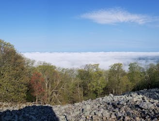
Maryland Heights above Harper's Ferry is an extremely popular sightseeing hike as it affords spectacular views of the town below and the Potomac River stretching away into the distance. You'll also enjoy a large dose of Civil War history along this hike.


Harper's Ferry is also one of the most famous stops along the Appalachian trail, and you're likely to spot a number of thru-hikers in town. That said, the hike to Maryland Heights actually isn't on the AT alignment, making for a unique and entertaining hike.
The heights themselves are located low on the mountainside, with the shortest route to reach them measuring only about 4.5 miles round-trip. For bonus miles, continue higher up the mountainside to reach the old stone fort.
Sources: https://www.nps.gov/hafe/planyourvisit/maryland-heights-trail.htm https://appalachiantrail.org/our-work/about-us/contact-us/harpers-ferry-visitor-center/
Difficult
Hiking trails where obstacles such as rocks or roots are prevalent. Some obstacles can require care to step over or around. At times, the trail can be worn and eroded. The grade of the trail is generally quite steep, and can often lead to strenuous hiking.
2 m away
Tour Civil War history and reach a spectacular overlook of Harper's Ferry.
Difficult Hiking
186 m away
Hike 41 miles through Maryland on the Appalachian Trail.
Moderate Hiking

58 routes · Hiking