4.6 km away
Grandview Rim Trail
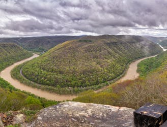
A beautiful overlook hike with commanding views of the New River.
Moderate Hiking
- Distance
- 4.9 km
- Ascent
- 240 m
- Descent
- 240 m
An easy hike along an abandoned railroad bed with numerous swimming holes and fishing opportunities.
Hiking Moderate

If you're searching for your own private swimming hole or a quiet riverside spot to cast a line, look no further than Glade Creek. Following an abandoned railroad bed along the river, this hike is sure to impress anyone in the family - including the dog! The abundance of unnamed cascades and small waterfalls make this one of the classic must-do hikes for anyone visiting New River Gorge.
As an out-and-back, this trail gives you the option to hike as much, or as little, as you'd like. With two vehicles, shuttling the trail is an option, though a high-clearance, 4WD vehicle is needed to reach the upper trailhead. Mud can also be an issue, which is why most opt for the out-and-back from the campground.
The main (lower) trailhead is at the Glade Creek Campground, where Glade Creek Road ends. Whether you come from Beckley or Fayetteville, you have 7 miles on unpaved road after driving through Prince, but a 2WD vehicle is more than adequate, according to most sources.
For those planning to fish along Glade Creek, the lower section of the river is a WV Catch & Release trout stream. More information on fishing in New River Gorge can be found here.
Moderate
Hiking along trails with some uneven terrain and small hills. Small rocks and roots may be present.

The trail contains some obstacles such as outcroppings and rock which could cause injury.

Little chance of being seen or helped in case of an accident.
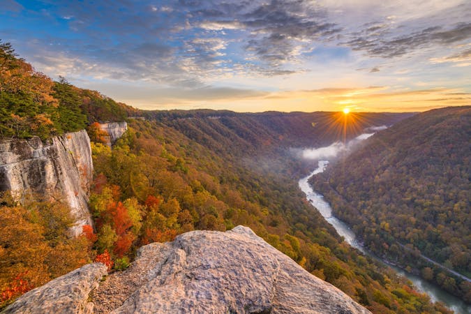
4.6 km away
A beautiful overlook hike with commanding views of the New River.
Moderate Hiking
10 routes · Hiking