576 m away
Once is Enough
Steep, steep, steep!
Extreme Freeride Skiing
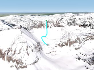
- Distance
- 547 m
- Ascent
- 4 m
- Descent
- 230 m
A perfect steep face.
Freeride Skiing Severe

No Name Face is a premier steep slope. This northern face is a long, consistent pitch worthy of high praise in corn or powder conditions, offering ample opportunity to let your spirit soar. The cirque in between (No Name Bowl) is shorter, but still worthy, and contains numerous cliff hucks, if you’re into that sort of thing. Getting there is simple but not always easy depending on conditions. The easiest way to access No Name Face is to take the Powder 8 Bootpack, then contour around the cirque on the southern side of Cody Peak. Go below Twice is Nice and Once is Enough, then up and over the cliffed terrain in the middle of the bowl. It’s also possible to wrap around the west side of Cody Peak via the Cardiac Ridge Bootpack. This approach is full of loose talus below a thin snowpack and is often confusing to find the right path through rocky terrain. However, if you’re into that sort of adventure, you will end up at the notch between Cody Peak and No Name Peak. From this notch, both access routes become one and you will begin to ascend up the east side of the ridgeline, which contains sections of sidestepping and boot packing until you reach a large cave. This cave is a great hangout and the starting point for the run. Enjoy the views and fuel up here, being sure to re-assess avalanche conditions and develop a plan for your group’s descent.
No Name Face is a classic run, but it’s not without danger. Access is difficult. The traverse from Powder 8 will put you below a large cliff cirque which sheds debris often, as well as crossing under two popular ski runs / avalanche paths. The traverse on the west side is convoluted and full of uneasy terrain. As for the descent, the skier’s righthand side of No Name Face is very exposed, meaning you should steer well clear of that danger by aiming for the immediate basin below (more north than northeast). If that’s not enough, the slope is prone to avalanching, so make sure conditions are appropriate before putting yourself in the line of fire!
Once done riding the face and in the basin below, traverse to the skier’s right below the large cliff band until reaching the top Pinedale Canyon. Continue through the canyon and traverse back to the resort.
Severe
Steep skiing at 38-45 degrees. This requires very good technique and the risk of falling has serious consequences.

As well as the slope itself, there are some obstacles (such as rock outcrops) which could aggravate injury.

Little chance of being seen or helped in case of an accident.
576 m away
Steep, steep, steep!
Extreme Freeride Skiing
638 m away

A traverse / Sidestep to bring you to No Name Face
Difficult Freeride Skiing
663 m away

A narrow winding path, through an improbable cliff.
Extreme Freeride Skiing
681 m away

Front and center; the epitome of an extreme ski line.
Extreme Freeride Skiing
771 m away

Slightly steeper and longer than No Shadows, but just as classic.
Severe Freeride Skiing
810 m away

Caution Advised!
Extreme Freeride Skiing
937 m away

A classic east facing pocket in Cody Bowl, and the least steep way down Cody Bowl
Difficult Freeride Skiing
1.1 km away

30 minutes to heaven.
Moderate Freeride Skiing
1.1 km away

An enticing face that is more dangerous than it appears.
Severe Freeride Skiing
1.4 km away

A great run, easy hike, fantastic views.
Difficult Freeride Skiing
20 routes · Freeride Skiing