Pala de la antena
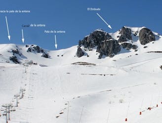
Línea accesible con buena nieve gracias a su orientación NE
Moderate Freeride Skiing
- Distance
- 874 m
- Ascent
- 66 m
- Descent
- 135 m

(Sector Cebolledo y Requejines)
Explore Estación Invernal y de Montaña San Isidro with curated guides of the best routes. With over 2 3D trail maps in FATMAP, you can easily discover and navigate the best trails in Estación Invernal y de Montaña San Isidro .
No matter what your next adventure has in store, you can find a guide on FATMAP to help you plan your next epic trip.
Get a top trail recommendation in Estación Invernal y de Montaña San Isidro , or get inspired by the 2 local adventures uploaded by the FATMAP community. Start exploring now!

Línea accesible con buena nieve gracias a su orientación NE
Moderate Freeride Skiing

Canal NE derecha Pico Agujas
Moderate Ski Touring