The tour around the Dachstein includes 188 kilometers and over an altitude of 4.700 meters. You cross the three states of Austria called Upper Austria, Styria and Salzburg.
Difficult Mountain Biking
- Distance
- 62 km
- Ascent
- 2.1 km
- Descent
- 1.8 km

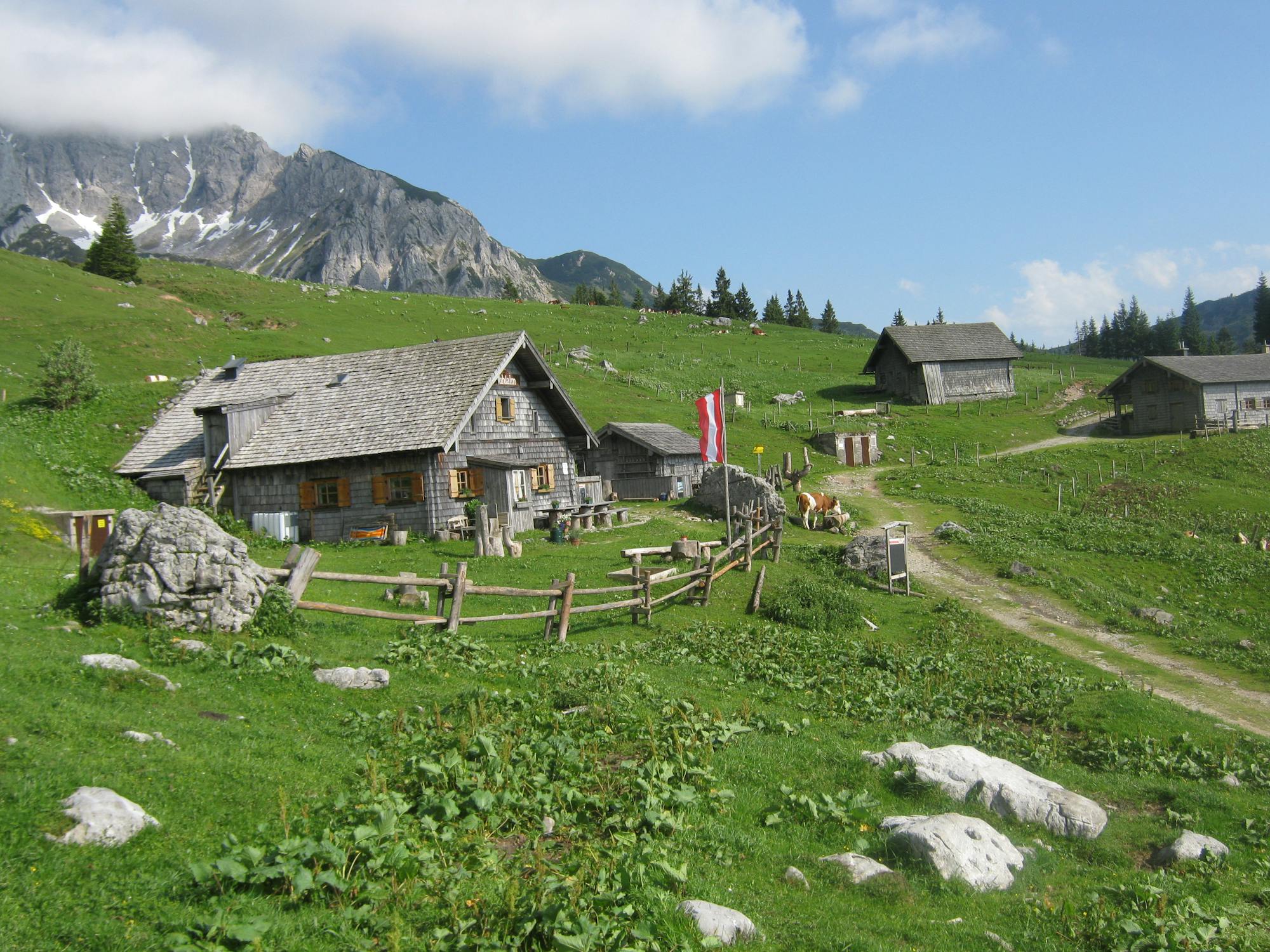
The Hütteneck is one of the loveliest locations in the Salzkammergut. There are old, rustic mountain huts, and breath-taking panoramic views across the entire Dachstein Salzkammergut holiday region.
Difficult Mountain Biking
- Distance
- 5.6 km
- Ascent
- 334 m
- Descent
- 115 m

Moderate Mountain Biking
- Distance
- 21 km
- Ascent
- 684 m
- Descent
- 684 m

You start the roundtrip directly in Bad Goisern to Weißenbach. It is a tour which takes about 1,5 hours. One of the most famous touris in Bad Goisern.
Difficult Mountain Biking
- Distance
- 19 km
- Ascent
- 551 m
- Descent
- 550 m

Enjoy traditional, regional cuisine and stunning views of King Dachstein.
Difficult Mountain Biking
- Distance
- 26 km
- Ascent
- 779 m
- Descent
- 779 m
Just 3 to 4 hours and still looking for a hike with a great view? Then the Jochwandtour is an ideal lap for a fast but beautiful hiking experience. The path was even certified by the German Hiking Institute.
Difficult Mountain Biking
- Distance
- 6.9 km
- Ascent
- 367 m
- Descent
- 367 m

Karl Pilz (1909-1993) worked in Bad Goisern as director of the local health spa from 1957-1974. He will always be remembered for his contribution to the development of local tourism. Approx. 3-4 hours duration.
Moderate Mountain Biking
- Distance
- 13 km
- Ascent
- 311 m
- Descent
- 311 m

It is a beautiful tour about 53 km. You start from Bad Goisern, over the famous Blaa Alm, over the Rettenbachalm to direction Hütteneck, Ewige Wand, Lauffen and Bad Goisern.
Extreme Mountain Biking
- Distance
- 53 km
- Ascent
- 1.9 km
- Descent
- 1.9 km

The track D of the Salzkammergut Mountainbike Trophy.
Severe Mountain Biking
- Distance
- 25 km
- Ascent
- 806 m
- Descent
- 806 m

A promising tour that takes its exit in St. Agatha near Bad Goisern am Hallstättersee and leads on 51 kilometers to the most beautiful pastures and viewpoints in the area. Among the highlights of the route is the Rettenbachtal, the long climb in the Grabenbachtal and the Eternal Wall
Extreme Mountain Biking
- Distance
- 52 km
- Ascent
- 2.1 km
- Descent
- 2.1 km

From Bad Goisern touristoffice you take the bike trail over an altitude of 1000 meters, after that you race down back again go Bad Goisern. Enjoy the tour!
Difficult Mountain Biking
- Distance
- 20 km
- Ascent
- 706 m
- Descent
- 706 m

The trail along the eastern side of the Hallstatt lake from Obersee to Obertraun is often described as one of the loveliest walks in the Salzkammergut.CURRENT INFORMATION: The Ostuferwanderweg is temporarily closed due to rock clearing and blasting work on the following dates.The path can be used, but you have to expect short waiting times. The works are in the area: Small weir ditch until Radwegunterführung Obersee. Clearing and blasting work: 07.05-10.05.2018,14.05.-17.05.2018,22.05-24.05.2018,10.09.-13.09.2018,17 09.-20.09.2018,24.09.-27.09.2018
Easy Hiking
- Distance
- 11 km
- Ascent
- 129 m
- Descent
- 130 m

Run and nordic walking tour at the lake Hallstättersee
Moderate Hiking
- Distance
- 9.6 km
- Ascent
- 125 m
- Descent
- 124 m

The Goisern mountain Hut is in view of the "Kalmberg Indian", and is one of the most popular hiking destinations in the Dachstein Salzkammergut region.
Difficult Hiking
- Distance
- 5.9 km
- Ascent
- 1.2 km
- Descent
- 3 m

Easy hiking tour in a beautiful landscape!
Difficult Hiking
- Distance
- 11 km
- Ascent
- 320 m
- Descent
- 320 m

This special walk through Bad Goisern starts at the tourist information in Höplingerhaus and takes about 1,5 hours.
Easy Hiking
- Distance
- 2.2 km
- Ascent
- 8 m
- Descent
- 8 m