1.2 km away
Bosc del Comellar

Amazing freeride lines through the forest.
Moderate Freeride Skiing
- Distance
- 1 km
- Ascent
- 0 m
- Descent
- 348 m
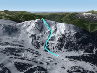
A classic off piste line to Tarter bottom station
Also in Encamp, Andorra
Freeride Skiing Moderate

This is a popular freeride skiing route which is generally considered to be moderate. It's remote, it features medium exposure (e2) and is typically done between December and March. From a low point of 1.7 km to the maximum altitude of 2.1 km, the route covers 1 km, 2 vertical metres of ascent and 355 vertical metres of descent. It's graded 1.2 and Labande grade 2.
A fun line through the forest with challenging terrain such as logs, little drops and pillows.
Moderate
Slopes become slightly steeper at around 25-30 degrees.

As well as the slope itself, there are some obstacles (such as rock outcrops) which could aggravate injury.
Away from help but easily accessed.
1.2 km away
Amazing freeride lines through the forest.
Moderate Freeride Skiing
1.3 km away

A deep, fun creek
Moderate Freeride Skiing
1.4 km away

A great freeride area for advanced riders
Difficult Freeride Skiing
1.5 km away

One of the El Tarter's classic off piste lines
Moderate Freeride Skiing
1.5 km away
Popular off piste with great terrain variety.
Difficult Freeride Skiing
1.5 km away

An area for experienced freeriders
Severe Freeride Skiing
1.5 km away

Dream forest lines
Moderate Freeride Skiing
1.6 km away

Lines among big rocks
Difficult Freeride Skiing
1.6 km away

Steep, varied terrain
Difficult Freeride Skiing
1.8 km away

A freeride area with easy terrain.
Easy Freeride Skiing
22 routes · Freeride Skiing