15 m away
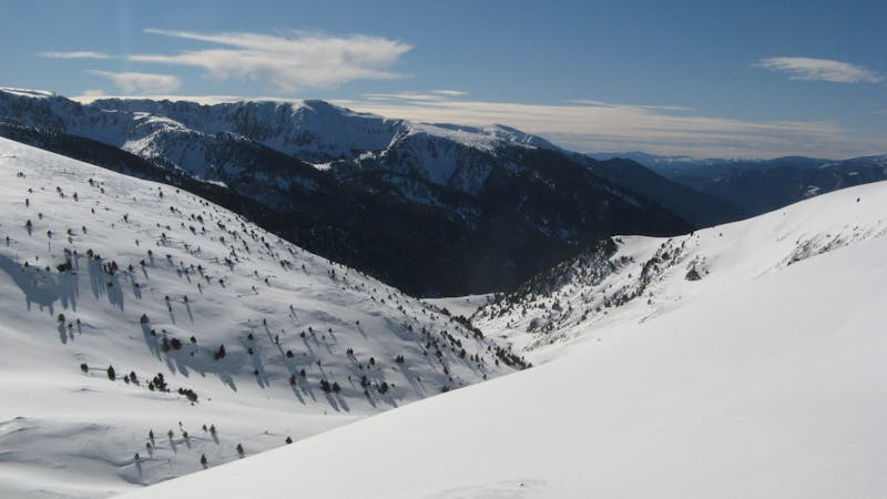
Pic de Cubil North-East

Steep terrain and couloirs from Pic de Cubil
Severe Freeride Skiing
- Distance
- 1.1 km
- Ascent
- 4 m
- Descent
- 396 m
Steep lines on alpine terrain
Freeride Skiing Severe

Pic de Cubil (2470m) has beautiful steep terrain to ride. Often the snow conditions are very challenging on the north-west face due to strong winds. From the top of Llac de Cubil or Cubil chairlifts the peak rises up steeply. The easy way up is to climb the north-west ridge. The way up is steep so crampons are recommended for icy sections as well as ice axe and other safety equipment for climbing. Although the way up can be challenging it does not offer any technical challenge beside steepness. On your way up you will have the north-west face on your left all time so take some time to study the terrain. This is a very rocky area overall so prior knowledge of conditions is vital. There are plenty of lines but all are technical because of the terrain and because there is a rocky line on the lower right (when coming down) of the face. Depending on the snow there are few spots where you can ride in between the rocks but there is a safe way out on the left side. This lines will finish on the Camí de Pessons piste Be aware of the danger of this line and communicate to the resort because there is a piste just crossing below; all precautions are welcome.
Severe
Steep skiing at 38-45 degrees. This requires very good technique and the risk of falling has serious consequences.

As well as the slope itself, there are some obstacles (such as rock outcrops) which could aggravate injury.
Away from help but easily accessed.
15 m away
Steep terrain and couloirs from Pic de Cubil
Severe Freeride Skiing
547 m away

An easy access off-piste area
Moderate Freeride Skiing
725 m away

Tree runs for advanced riders.
Moderate Freeride Skiing
798 m away

Extreme freeride lines through couloirs and steep slopes
Severe Freeride Skiing
862 m away

An extreme freeride line for experienced riders
Severe Freeride Skiing
2.3 km away

Easy access freeride area for intermediate riders
Moderate Freeride Skiing
2.4 km away

Backcountry route for experienced riders
Difficult Freeride Skiing
2.4 km away

Fun off-piste through the woods
Easy Freeride Skiing
2.4 km away

A classic long off-piste area with easy terrain
Easy Freeride Skiing
2.5 km away

An easy acces off-piste area
Moderate Freeride Skiing
22 routes · Freeride Skiing