10 m away
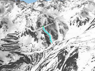
L'hortell's gully line

A short and steep gully line where good skiing skills are required.
Extreme Freeride Skiing
- Distance
- 977 m
- Ascent
- 226 m
- Descent
- 227 m
A line with a long approach and some steep sections.
Freeride Skiing Severe

A long walk is needed from the lift "L'Abarsetar". Turn right and hike for about 30 minutes to the top of the "Pic de l'hortell", then a long hike of 30 minutes is needed to reach the large gully empty of rocks. The line is steep but not over 45 degrees however good skills are required as cliffs can be found in the middle of the line but they are optional. The line gets fairly well protected from the sun due to the cliffs to its skiers L. Added to the altitude of the line this can cause some important avalanche risks. A good weather window is important due to the long hike to reach the bottom of the face, lower part of the line is losing less steepness and gets much easier. The line finishes on the blue piste "Les Canals" which leads back to the main Arcalis ski area.
Severe
Steep skiing at 38-45 degrees. This requires very good technique and the risk of falling has serious consequences.

As well as the slope itself, there are some obstacles (such as rock outcrops) which could aggravate injury.
Away from help but easily accessed.
10 m away
A short and steep gully line where good skiing skills are required.
Extreme Freeride Skiing
76 m away

A long and gentle line close some trees into a mellow area.
Moderate Freeride Skiing
483 m away

A long walk line with some rough terrain suitable only for good skiers.
Extreme Freeride Skiing
508 m away

A forest line with some really steep sections that feels like a piste in the lower section.
Extreme Freeride Skiing
1.5 km away

A nice line where a good walk is required with a short section of steep skiing.
Severe Freeride Skiing
1.5 km away

A small short cut line close to the slope without many difficulties, other than navigation
Moderate Freeride Skiing
1.5 km away

Long traverse line where a small and steep line can be found into a small gully.
Severe Freeride Skiing
1.5 km away

Small line into an arete with some steepness into a gully.
Extreme Freeride Skiing
1.5 km away

A line with a long walk needed and with some real steepness in the line itself.
Extreme Freeride Skiing
1.6 km away
Shortcut line between slopes close to the trees including some steepness.
Severe Freeride Skiing

20 routes · Freeride Skiing