10 m away
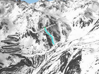
L'hortell N face.

A line with a long approach and some steep sections.
Severe Freeride Skiing
- Distance
- 1.8 km
- Ascent
- 272 m
- Descent
- 324 m
A short and steep gully line where good skiing skills are required.
Freeride Skiing Extreme

As so often in this ski resort this is an easily accessed line, just go left on top of "L'Abarsetar" lift. A hike of about 30 minutes is needed to reach the top of the "Pic de l'hortell", where the line starts. Steepness is the key point of the line, which starts in the first gully to the right of the "Pic de l'hortell". Good weather is needed as the line faces west and gets a lot of sun. Avalanche risk is pretty important due to the altitude and the steepness of the gully, and good navigation skills are important as the line is into a gully and a mistake could make you fall to the bottom. The lower part of the line loses some steepness and becomes more gentle. The line finishes on the blue piste "Les Canals" which leads back to the main ski area of Arcalis.
Extreme
Extreme skiing terrain above 45 degrees. These routes are reserved for experienced experts.

As well as the slope itself, there are some obstacles (such as rock outcrops) which could aggravate injury.
Away from help but easily accessed.
10 m away
A line with a long approach and some steep sections.
Severe Freeride Skiing
72 m away

A long and gentle line close some trees into a mellow area.
Moderate Freeride Skiing
473 m away

A long walk line with some rough terrain suitable only for good skiers.
Extreme Freeride Skiing
517 m away

A forest line with some really steep sections that feels like a piste in the lower section.
Extreme Freeride Skiing
1.5 km away

A nice line where a good walk is required with a short section of steep skiing.
Severe Freeride Skiing
1.5 km away

A small short cut line close to the slope without many difficulties, other than navigation
Moderate Freeride Skiing
1.5 km away

Long traverse line where a small and steep line can be found into a small gully.
Severe Freeride Skiing
1.5 km away

A line with a long walk needed and with some real steepness in the line itself.
Extreme Freeride Skiing
1.5 km away

Small line into an arete with some steepness into a gully.
Extreme Freeride Skiing
1.6 km away
Shortcut line between slopes close to the trees including some steepness.
Severe Freeride Skiing

20 routes · Freeride Skiing