167 m away
La Canaleta's lower section line
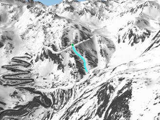
Shortcut line between slopes close to the trees including some steepness.
Severe Freeride Skiing
- Distance
- 236 m
- Ascent
- 0 m
- Descent
- 113 m
Short cut line between slopes, close the trees with some steepness.
Freeride Skiing Severe

This is an easily accessed line as you just need to follow green slope "La Basera" and turn left 50 meters after entering into the track area of the slope. The line is pretty short but gets some steepness in the first section, where snow cover is an important part of the line, as we are below 2000 meters. A good base is needed before entering the area. The line faces north, which keeps away the sun but the area can be frozen in the morning. Avalanche risk is pretty low around here other than in the higher part due to the steepness. The main hazard to be aware of is the junction with the red slope "La Canaleta" where collisions might happen with other skiers. The line finishes on the red piste "La Canaleta" which leads back to the bottom of Arcalis ski resort.
Severe
Steep skiing at 38-45 degrees. This requires very good technique and the risk of falling has serious consequences.

As well as the slope itself, there are some obstacles (such as rock outcrops) which could aggravate injury.

Close to help in case of emergency.
167 m away
Shortcut line between slopes close to the trees including some steepness.
Severe Freeride Skiing
509 m away

Short line with some steepness into the lowest section which is often in the sun.
Severe Freeride Skiing
522 m away

A short line which feels like a piste but is slightly steep at the end.
Severe Freeride Skiing
749 m away

Long traverse line where a small and steep line can be found into a small gully.
Severe Freeride Skiing
890 m away

A easy and gentle line close to the slope passing alongside a river.
Moderate Freeride Skiing
918 m away

Small line into an arete with some steepness into a gully.
Extreme Freeride Skiing
1.1 km away

Easy line close to the slopes, with a steep entrance being the only slightly tricky bit.
Difficult Freeride Skiing
1.2 km away

A long traverse line with a really steep entrance onto a ridge side.
Extreme Freeride Skiing
1.2 km away

A long line with a small cliff in the middle.
Severe Freeride Skiing
1.3 km away

A long traverse line close to the slopes, initially on top of a ridge before some steep and rocky skiing.
Extreme Freeride Skiing

20 routes · Freeride Skiing