6.1 km away
The Amphitheatre

Collecting a huge amount of snow, this area holds the snow really late into the season and The Amphitheatre is a lovely set of chutes.
Severe Freeride Skiing
- Distance
- 1.1 km
- Ascent
- 0 m
- Descent
- 299 m
A creek line run with sections of tree skiing
Freeride Skiing Moderate

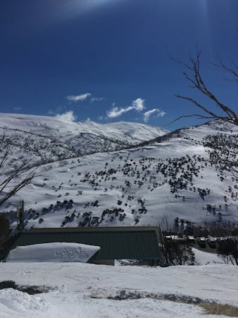
This is a popular freeride skiing route which is generally considered to be moderate. It's very remote, it features medium exposure (e2) and is typically done between June and September. From a low point of 1.6 km to the maximum altitude of 1.9 km, the route covers 1.3 km, 0 vertical metres of ascent and 273 vertical metres of descent. It's graded 2.3 and Labande grade 3. You'll need skins to complete it safely.
Beginning with open turns near the trig, this line then turns down to moderate tree skiing. Ensure you begin to head towards the dam before 1600M as there are rocks and exposed step faces closer to the snowy river. Snow is often marginal at lower elevations.
Moderate
Slopes become slightly steeper at around 25-30 degrees.

As well as the slope itself, there are some obstacles (such as rock outcrops) which could aggravate injury.

Little chance of being seen or helped in case of an accident.
6.1 km away
Collecting a huge amount of snow, this area holds the snow really late into the season and The Amphitheatre is a lovely set of chutes.
Severe Freeride Skiing
6.1 km away

Following a narrow gully running down from Twynam, The Scimitar plummets down for over 400 metres of vertical to Watson's Creek
Difficult Freeride Skiing
6.1 km away

A great run to assess the conditions before dropping into the Blue Lake area
Moderate Freeride Skiing
6.1 km away

The easiest line down to Blue Lake
Moderate Freeride Skiing
6.1 km away

Offering some of the greatest continuous fall line in Australia, The Triple A is fantastic in Spring, holding a consistent pitch all the way through.
Difficult Freeride Skiing
6.1 km away

The northeastern spur off Mt Twynam follows a gentle gradient for around 2 km to the base of Mt Anderson
Moderate Freeride Skiing
6.6 km away

A popular line for a serious backcountry skier or boarder, Stag Gully is the gnarliest of them all.
Severe Freeride Skiing
6.9 km away

The most common run into the Watsons Creek Bowl
Difficult Freeride Skiing
6.9 km away

The most western of the steep chutes down into Blue Lake.
Difficult Freeride Skiing
7.1 km away

One of the most picturesque lines you will ever do.
Moderate Freeride Skiing
6 routes · Freeride Skiing · Ski Touring
16 routes · Freeride Skiing · Ski Touring