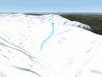
Although many people use this run to drop into the southern Sentinel ridge or the more gnarly northern side, yet the ridgeline itself, although it doesn't hold the best now, it has some really fun technical sections with a few hundred metres of vertical from the shoulder of Twynam. To get to the ridgeline, head west from the western flanks of Twynam and the ridge will head out to the north west, it is really obvious, and the line shown on the map is a really safe bet. Conditions can be seriously dicey when it is icy, and the run down is best enjoyed on a sunny blue bird day, conditions change rapidly up there so take care and enjoy the show, it's incredible.