92 m away
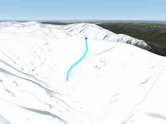
Watsons Creek Run B

Dropping down into Watsons Creek, keeping skiers left of the creek
Difficult Freeride Skiing
- Distance
- 1.1 km
- Ascent
- 7 m
- Descent
- 375 m

Falling away to the west of Tenison Woods Knoll, it acts as the western boundary of The Avalanche Face, heading steeply down to Strzelecki Creek
Freeride Skiing Severe

Ant Ridge acts as the western boundary of The Avalanche Face, a jagged ridge which from above seems exposed and doesn't seem to provide many options yet on the western side of the ridge, there are some steep lines following the drainage depressions which can collect snow even when the ridge is wind affected. Dropping into Ant Ridge is fairly easy as it is an obvious ridge line protruding from the Avalanche Face which is visible almost immediately from the western face of Tenison Woods knoll. These lines are some of the steepest on the range, so experience is definitely required, and scoping out the lines from The Sentinel is often a very good idea. There is a lot of vertical in a typical season with these lines too which make for some intense skiing or boarding. The return trip is best done via hiking back up Ant Ridge, or up The Avalanche Face. Take care if you drop down into Strzelecki Creek as it can become very rugged down there, and should be left for those experienced in the area.
Severe
Steep skiing at 38-45 degrees. This requires very good technique and the risk of falling has serious consequences.
92 m away

Dropping down into Watsons Creek, keeping skiers left of the creek
Difficult Freeride Skiing
238 m away

Dropping South West of Tenison Woods Knoll, this provides a fairly open face with a variety of lines on offer leading down to Strzelecki Creek
Difficult Freeride Skiing
381 m away

Featuring a large, steep rugged outcrop on the West slopes, steep long lines down to Strzelecki Creek
Severe Freeride Skiing
382 m away

Beginning north west of Tenison Woods Knoll, this area drops down steeply into Siren Song Creek catchment.
Difficult Freeride Skiing
446 m away

Providing some of the gnarliest terrain in the Main Range, this hidden area can provide some steep relatively hazard free skiing, or some of the most intense lines you can find in Australia.
Extreme Freeride Skiing
502 m away

Strzelecki Creek drops sharply granting an absolutely breathtaking view of the Sentinel before plunging westwards into some of the best terrain in Australia.
Difficult Freeride Skiing
515 m away

One of the most picturesque lines you will ever do.
Moderate Freeride Skiing
723 m away

The most common run into the Watsons Creek Bowl
Difficult Freeride Skiing
937 m away

Some of the most unforgiving lines on the continent.
Extreme Freeride Skiing
1.2 km away

Often loaded with snow, consistent fall lines and about 400 metres of vertical down into James Macarthur Creek
Difficult Freeride Skiing

16 routes · Freeride Skiing · Ski Touring