1 m away
Walter's Gully

Featuring a large, steep rugged outcrop on the West slopes, steep long lines down to Strzelecki Creek
Severe Freeride Skiing
- Distance
- 950 m
- Ascent
- 0 m
- Descent
- 402 m
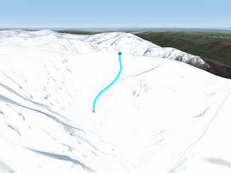
Beginning north west of Tenison Woods Knoll, this area drops down steeply into Siren Song Creek catchment.
Freeride Skiing Difficult

Beginning about 500 metres north west of Tenison Woods Knoll, you will pass the ridge which separates the catchment of Watsons and Siren Song Creek. Once passing this ridge, this acts as the entry point down to the run shown on the map. In reality, you can go further along the ridge to get to Siren Song Catchment proper. This line is a gem nonetheless, begin by dropping down along the ridge for a few hundred metres before turning left and down into the steep face below. Towards the end of the ridge, you will see it drop away ahead of you, drop in to the skiers left and head down towards Siren Song Creek for a short stint, before heading down to the right, and the faces will drop down ahead of you, with the rocky outcrop at the end of the ridge behind you. This face is a real gem, it can hold some incredible snow, and if you pick your line right, you can get a really good pitch, with a consistent fall line down to the creek. This run is often overlooked, but this is a really great line, and heading back up the face is possible and you can start lapping the steep terrain of the rest of Siren Song Catchment, but this is an absolute ripper in the right conditions. Stay avalanche conscious and as ever, assess the snow conditions before you head out. The terrain is relatively hazard free, but early season sharks are prominent out there. The lower section of this run loses snow relatively quickly later in the season, and if this does occur, you will be better off lapping the Siren Song terrain above the sub ridge.
Difficult
Serious gradient of 30-38 degrees where a real risk of slipping exists.

As well as the slope itself, there are some obstacles (such as rock outcrops) which could aggravate injury.

Little chance of being seen or helped in case of an accident.
1 m away
Featuring a large, steep rugged outcrop on the West slopes, steep long lines down to Strzelecki Creek
Severe Freeride Skiing
99 m away

Providing some of the gnarliest terrain in the Main Range, this hidden area can provide some steep relatively hazard free skiing, or some of the most intense lines you can find in Australia.
Extreme Freeride Skiing
382 m away

Falling away to the west of Tenison Woods Knoll, it acts as the western boundary of The Avalanche Face, heading steeply down to Strzelecki Creek
Severe Freeride Skiing
471 m away
Dropping down into Watsons Creek, keeping skiers left of the creek
Difficult Freeride Skiing
607 m away

Dropping South West of Tenison Woods Knoll, this provides a fairly open face with a variety of lines on offer leading down to Strzelecki Creek
Difficult Freeride Skiing
856 m away

Strzelecki Creek drops sharply granting an absolutely breathtaking view of the Sentinel before plunging westwards into some of the best terrain in Australia.
Difficult Freeride Skiing
866 m away

One of the most picturesque lines you will ever do.
Moderate Freeride Skiing
1 km away

The most common run into the Watsons Creek Bowl
Difficult Freeride Skiing
1.3 km away

Some of the most unforgiving lines on the continent.
Extreme Freeride Skiing
1.4 km away

Often loaded with snow, consistent fall lines and about 400 metres of vertical down into James Macarthur Creek
Difficult Freeride Skiing
16 routes · Freeride Skiing · Ski Touring