24 m away
26
This is a popular freeride run after a big dump because it is easy accessible.
Difficult Freeride Skiing
- Distance
- 563 m
- Ascent
- 0 m
- Descent
- 248 m
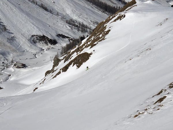
This is a popular free ride run, like the 26 run, in the resort after a big dump because it is easy accessible.
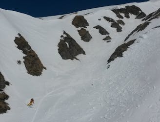
Freeride Skiing Difficult

This is steeper then the 26 run and you have to also be aware at the end of the run when you are connecting to the slope, there are some gullies. In summer this is a small creek running down out of the valley.
Follows this 32 - Red slope until you are about to cross the Höllspitze ridge. This is where the 32 - Red makes a bend to the skiers right, down towards Höllkar valley. Stop there and follow the Höllspihtze ridge further down for about 10 meters towards Höellboden 2141 m. Its possible you have to go over a pile of snow that the snowcats made to prepare the 32 - Red. Now you are at the top of the run 26, 2560 m. Follow the ridge down for another 250 m and you are at the top of the run on the skiers right. Side note, anything on the skiers right side coming down the ridge is perfect freeride terrain, and features the same challenges as the 26 a run.
When you ski down you have the left and the right to bail when there is a slide. But keep in mind that when you are getting close to the bottom of the run, the transition is more aggressive from a 28 to 35 degrees slope to a 10 degree and almost flat slope the 23 - Blue at around 2210 m. Also be aware of the small gully just before you connect.
Difficult
Serious gradient of 30-38 degrees where a real risk of slipping exists.

As well as the slope itself, there are some obstacles (such as rock outcrops) which could aggravate injury.
Away from help but easily accessed.
24 m away
This is a popular freeride run after a big dump because it is easy accessible.
Difficult Freeride Skiing
1.6 km away
A brilliant couloir which is best skied in spring snow.
Severe Freeride Skiing
2 km away
Popular freeride run in the resort.
Difficult Freeride Skiing
2.4 km away
This is a popular freeride run for beginners. Its easily accessible and does not require a hike or bootpack.
Moderate Freeride Skiing
2.9 km away
A hard ski route with a nice angle for skiing.
Difficult Freeride Skiing
3.1 km away
A short ski route from Pardatschgratbahn, Pardoramabahn or Gratbahn towards Idalp.
Moderate Freeride Skiing
4.2 km away
A straightforward short run into the Obese Velillalp.
Moderate Freeride Skiing

50 routes · Freeride Skiing · Ski Touring
8 routes · Freeride Skiing

10 routes · Freeride Skiing