779 m away
Gampenbahn Rinne
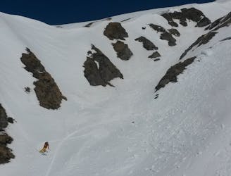
A brilliant couloir which is best skied in spring snow.
Severe Freeride Skiing
- Distance
- 2.4 km
- Ascent
- 2 m
- Descent
- 835 m
This is a popular freeride run for beginners. Its easily accessible and does not require a hike or bootpack.
Also in Tirol, Austria
Freeride Skiing Moderate

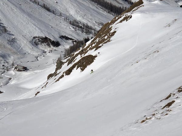
Catch the Palinkopfbahn. When you exit the chairlift ski the 40 - Red on the skiers left. The slope makes 2 bends, one to the right and one to the left, here you will pass the freeride run nr 39. Keep going until you come to a bigger bend to the right and you have a junction where you can take the marked slope nr 41 - Red. Don't take the 41 - Red, but keep going for 50 m on the 40 - Red and then on the skiers left side there is an opening in the fence and a sign where the ski route is marked upon. This is the top of the line. When you ski down, you can see the Piz Val Grondabahn as your aim point. The steepest section is max 30 degrees. This is a safer option to ski when there is a higher avalanche warning.
Moderate
Slopes become slightly steeper at around 25-30 degrees.

Exposure is limited to that of the slope itself. Getting hurt is still likely if the slope is steep and/or the snow is hard.
Close to help in case of emergency.
779 m away
A brilliant couloir which is best skied in spring snow.
Severe Freeride Skiing
2.4 km away
This is a popular free ride run, like the 26 run, in the resort after a big dump because it is easy accessible.
Difficult Freeride Skiing
2.4 km away
This is a popular freeride run after a big dump because it is easy accessible.
Difficult Freeride Skiing
4.1 km away
Popular freeride run in the resort.
Difficult Freeride Skiing
4.9 km away
A hard ski route with a nice angle for skiing.
Difficult Freeride Skiing
5.5 km away
A short ski route from Pardatschgratbahn, Pardoramabahn or Gratbahn towards Idalp.
Moderate Freeride Skiing
6.6 km away
A straightforward short run into the Obese Velillalp.
Moderate Freeride Skiing

50 routes · Freeride Skiing · Ski Touring
8 routes · Freeride Skiing

10 routes · Freeride Skiing