1.1 km away
Zuckerhütl
A wonderful, varied and scenic tour to the highest peak in the Stubai range.
Difficult Ski Touring
- Distance
- 8.2 km
- Ascent
- 920 m
- Descent
- 920 m
A couple hours adventure down to the windach valley with the possibility to continue to Sölden
Ski Touring Moderate

You can take the Schaufeljochbahn Gondola in order to skip the 1100m of skinning up ski pistes.


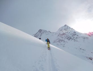
You can start at the top of the gondola and follow the gaiskarferner süd pistes until the very end then take a right and follow the small valley that is on the right of the pistes ; beware of windloading of surrounding slopes. (The snowpack was very reactive for us but luckily the only in the lower sections where the angle was <30°).
Cross the plateau (no need for skinning) until the couloirs entrance.
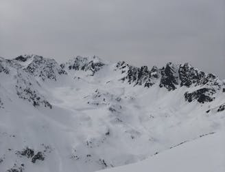
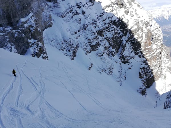
The couloir is nice and wide in the range of 30 to 35°, though the entrance and the slopes on the skiers left can be prone to some wind loading. And the right bank is more exposed to ice debris and rock fall during a warm day.
Strait under the couloir beware of the morraine terrain that hides some deep gullys, beware of not falling into them. In good conditions there is no need to skin.
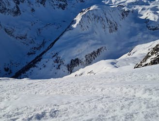
Navigate your way down following the river bed, beware of not falling into the river but more importantly do not go to far right where it gets steeper as you will end up in bushes and rock slabs.
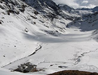
This track ends at the bottom of the materialseilbahn of hildesheimer hütte (material lift not for people and not in use during winter). There are a couple buildings close to which we set camp for the night but you can keep on going down the valley following the large path will be your best bet and will require almost no skinning.
All in all this is and nice small adventurous route accessible with ski lifts but in wild terrain that requires avalanche knowledge and the obvious minimum avalanche gear: beacon, probe, shovel. This track is part of a much larger project crossing the Alps done in 2024.
Moderate
Slopes become slightly steeper at around 25-30 degrees.

Exposure is limited to that of the slope itself. Getting hurt is still likely if the slope is steep and/or the snow is hard.
Close to help in case of emergency.
1.1 km away
A wonderful, varied and scenic tour to the highest peak in the Stubai range.
Difficult Ski Touring
2.4 km away
A long tour through the northern Stubai Alps.
Extreme Ski Touring
2.8 km away
This is a mainly downhill day to get the ski legs in, with the option of a ski summit by going up a side valley.
Moderate Ski Touring
5 km away
Get top to the top of this iconic peak in the Stubaier Alps!
Difficult Ski Touring
7.7 km away

Skitour über den Schwarzenbergerferner und Gratkletterei auf einen Gipfel mit einer Rundumsicht, die ihresgleichen sucht!
Difficult Ski Touring
7.7 km away

Über Eis und Steilrinnen auf einen Panoramagipfel der Stubaier Alpen
Difficult Ski Touring
7.7 km away

Eine einfache, unvergletscherte Skitour im Schatten steiler Felswände.
Moderate Ski Touring
7.7 km away

Einsame sonnseitige Frühjahrsabfahrt.
Moderate Ski Touring
7.7 km away
A day tour up the classic Kuhscheibenspitze, 3189m
Difficult Ski Touring
7.7 km away
A long glacial skin to a short roped climb leading to one of two cols, before a long descent to the Franz Senn Hut.
Difficult Ski Touring
5 routes · Ski Touring

17 routes · Ski Touring

25 routes · Ski Touring
6 routes · Ski Touring