604 m away
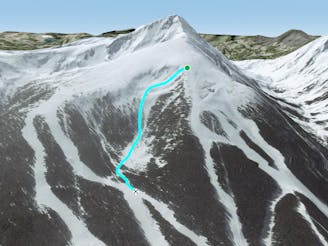
Todorka peak North face

Todorka peak iis the closest peak to the resort of Bansko and one of the most picturesque summit in Pirin mountains
Severe Freeride Skiing
- Distance
- 1.6 km
- Ascent
- 208 m
- Descent
- 347 m
A long and steep descent from top to bottom, an epic ski line.
Freeride Skiing Difficult

Start of the top station of Banderitsa 2 ski lift and hike up, following the distinctive airy north ridge, to the summit of Todorka (2746 metres). The use of crampons is highly recommended. From the peak ski down the ridge going south to reach a broad col. Take skis off and hike uphill for 5 minutes, still heading south, to reach a small summit on the ridge. Ski from here, entering the face either on the left or right hand side and ski all the way to the valley floor. Beware that at the entry sometimes there's a cornice and also many hidden rocks/sharks. In the late season it can be very icy in the mornings. Having reached the valley floor the bottom of the valley, you have to continue north to Vihren hut, which is actually visible from the summit ridge of Todorka. From the hut follow the road easily for roughly 4 kilometres to the ski resort, where you join the Tomba piste.
Beware of the fact that the Bulgarian rescue service has no rescue helicopter, and it can take a long time to reach casualties.
Difficult
Serious gradient of 30-38 degrees where a real risk of slipping exists.

As well as the slope itself, there are some obstacles (such as rock outcrops) which could aggravate injury.

Little chance of being seen or helped in case of an accident.
604 m away
Todorka peak iis the closest peak to the resort of Bansko and one of the most picturesque summit in Pirin mountains
Severe Freeride Skiing
761 m away

Easy access from the resort and an easy wide open descent.
Easy Freeride Skiing
1.3 km away
A demanding but short and easy-access run.
Difficult Freeride Skiing
4 routes · Freeride Skiing