16 m away
Grotto Canyon | C'est Notre Monde
Grotto Canyon, hiking on a frozen river in Kananaskis Country
Easy Hiking
- Distance
- 5.2 km
- Ascent
- 253 m
- Descent
- 253 m
A stenuous scrambling to breathtaking views
Hiking Difficult

VIDEO: https://youtu.be/Jk9cUm8GE2k
ENGLISH https://www.cnotremonde.com/en/itineraries/alberta-en/gap-peak-2/ Looking for an adventure at the doorstep of the Canadian Rockies? Explore the breathtaking summit of Gap Peak, towering at 2517 meters! Nestled in the Bow Valley Provincial Park, at the heart of Kananaskis Country, this mountain invites you to conquer its steep trails, rugged scree slopes, and dizzying ridge. With intermediate scrambling and a challenging hike, Gap Peak in the Canadian Rockies offers a unique experience. Discover all the essential tips to appreciate this unforgettable adventure at Gap Peak.
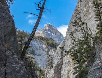
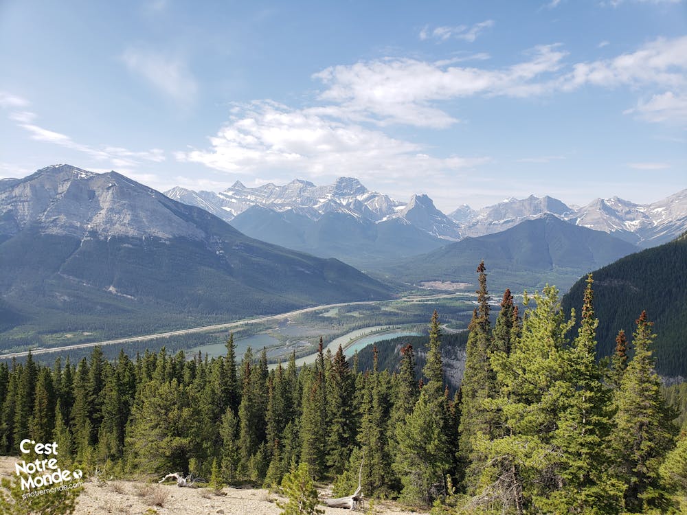
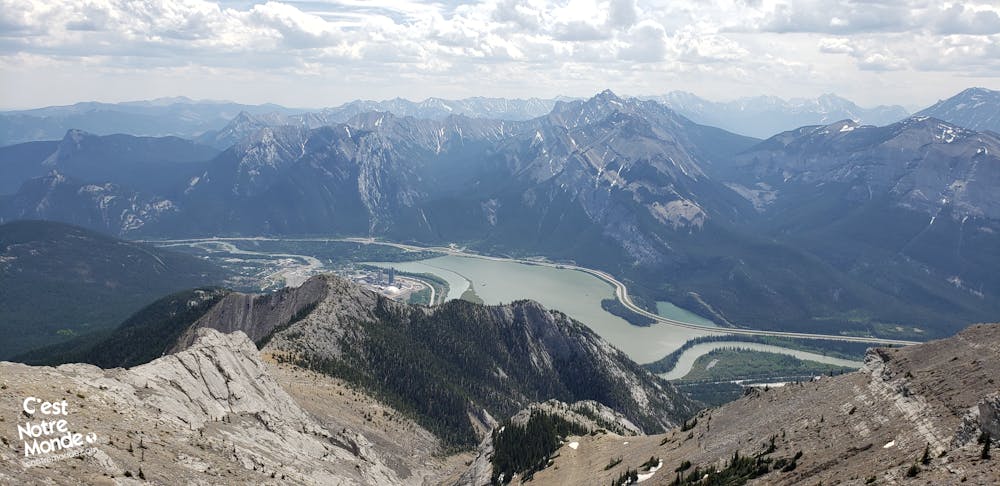
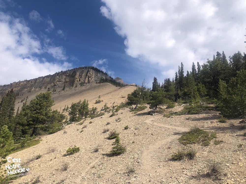
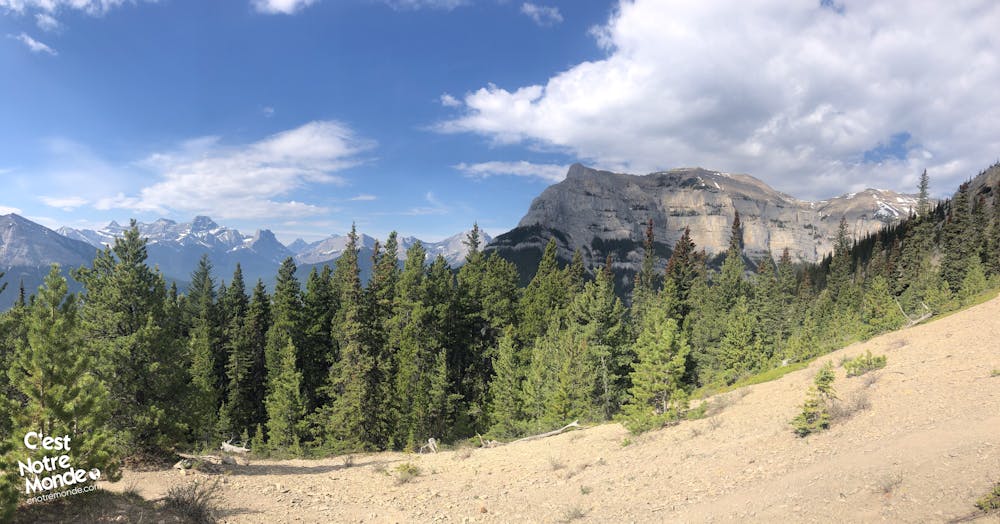
DIRECTIONS Embark on the Gap Peak hike by starting on the Grotto Canyon trail leading to the Baymag plant, a magnesium oxide extraction site. After 450 meters (0.3 mi), a large open space appears on your right; pass the access barrier and move closer to the forest. The trail to the summit of Gap Peak is identifiable by a rock marked "GP" at its beginning! Follow this well-marked forest trail for about 2 km (1.2 mi) with an elevation gain of 600 meters (1971 ft). Although the noise from the plant briefly disrupts the immersion in nature, it quickly dissipates. Upon exiting the forest, you'll discover the first panoramic view of the Bow Valley and the surrounding peaks.
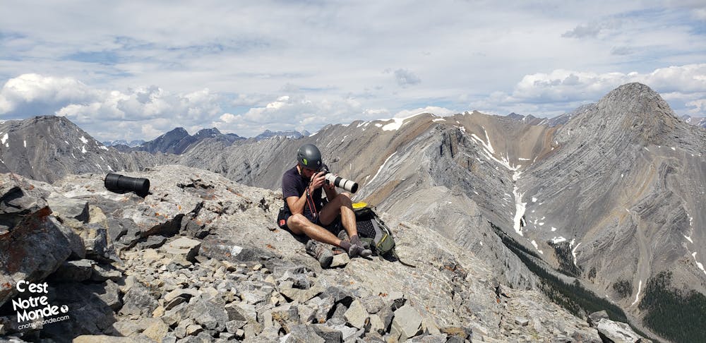
Continue along the trail, gradually approaching a cliff. Wear a helmet from this point onward. Follow the cliff for about 100 meters, then re-enter the forest. Next, traverse a very steep section to reach a promontory with a beautiful view of the valley. Proceed along another cliff to reach a section of steep scree, challenging due to the instability of the rocks. Take your time, watch for rock falls.
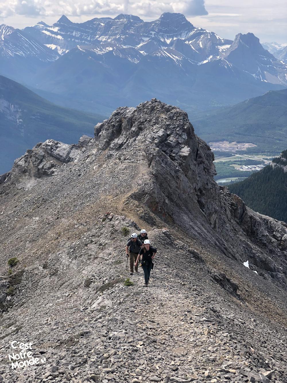
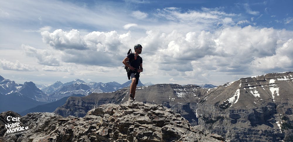
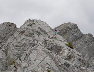
At the top of this long and strenuous scree section (visible from the Trans-Canada Highway), engage in an easy scrambling (where you need to use your hands) to reach the ridge of Gap Peak. At this point, you've already climbed 1000 meters in elevation over about 3 km. All that's left now is to walk along the ridge to the summit (approximately 650 meters - 0.4 miles). This ridge may be intimidating for those afraid of heights, so take your time and enjoy the views!
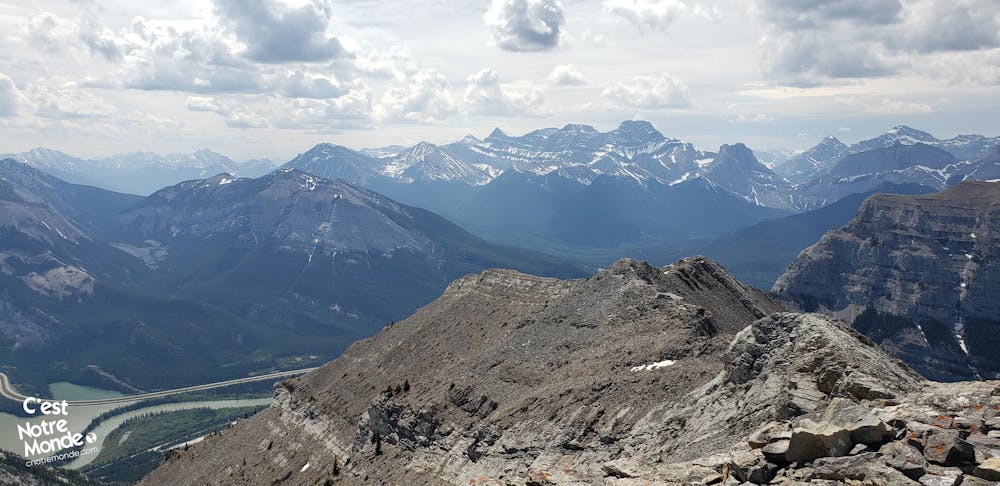
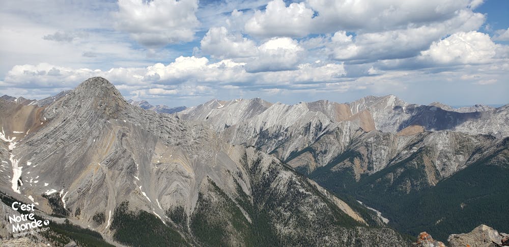
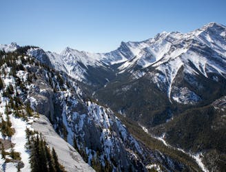
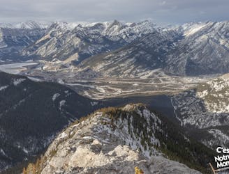
At 2517 meters, reach the summit of Gap Peak with a panoramic view, including Grotto Mountain, Heart Mountain, Big Sister, and much more. Bid farewell to the factory, hidden behind the ridge, and finally embrace the true feeling of Nature!
For the return, retrace your steps. Avoid venturing east of the summit, as it leads to difficult terrain off the beaten track. C'est Notre Monde took that path, requiring bushwhacking to find the official route—strongly not recommended despite appearances on several online maps.
FRANÇAIS https://www.cnotremonde.com/randonnees/alberta/gap-peak/ À la recherche d'une aventure aux portes des Rocheuses Canadiennes ? Explore le sommet époustouflant de Gap Peak, qui culmine à 2517 mètres ! Nichée dans le Bow Valley Provincial Park, au cœur du Kananaskis Country, cette montagne t'invite à conquérir ses sentiers escarpés, ses éboulis abrupts et sa crête vertigineuse. Avec un scrambling intermédiaire et une randonnée pleine de défis, Gap Peak dans les Rocheuses canadiennes offre une expérience unique. Découvre tous les conseils essentiels pour maîtriser cette aventure inoubliable à Gap Peak.
ITINÉRAIRE Lance-toi dans la randonnée de Gap Peak en commençant par un chemin de Grotto Canyon menant à l'usine Baymag, un site d'extraction d'oxyde de magnésium. Après 450m (0,3 mi), un grand espace dégagé appararait sur ta droite, passe le barrière d'accès et rapproche toi de la forêt. Le sentier vers le sommet de Gap Peak est repérable grâce à un rocher marqué "GP" à son début ! Suis ce sentier forestier bien balisé sur environ 2 km (1,2 mi) avec un gain d'altitude de 600 m (1971 ft). Bien que le bruit de l'usine perturbe brièvement l'immersion dans la nature, il se dissipe rapidement. En sortant de la forêt, tu découvriras la première vue panoramique sur la Bow Valley et les sommets environnants.
Continue le long du sentier, approchant progressivement d'une falaise. Porte un casque à partir de ce point. Suis la falaise sur environ 100 mètres, revenant dans la forêt. Traverse ensuite une section très raide pour atteindre un promontoire avec une belle vue sur la vallée. Poursuis le long d'une autre falaise pour atteindre une section de scree abrupte, difficile en raison de l'instabilité des rochers. Prends ton temps, sois vigilant contre les chutes de rochers.
Au sommet de cette longue et douloureuse section de pierrier (visible depuis la Transcanadienne en passant), engage toi sur un scrambling facile (où tu dois utiliser tes mains) pour atteindre la crête de Gap Peak. À ce stade, tu as déjà grimpé 1000 mètres de dénivelé sur environ 3 km. Tout ce qu'il te reste à faire maintenant, c'est marcher le long de la crête jusqu'au sommet (environ 650m - 0,4mi). Cette crête peut intimider ceux qui ont le vertige, alors prends ton temps et profite des vues !
À 2517 mètres, atteins le sommet de Gap Peak avec une vue panoramique, incluant Grotto Mountain, Heart Mountain, Big Sister, et bien plus encore. Dis adieu à l'usine cachée derrière la crête, et embrasse enfin la vraie sensation de pleine nature !
Pour le retour, retrouve tes pas. Évite de t'aventurer à l'est du sommet, car cela te mènera à un terrain difficile hors des sentiers battus. C'est Notre Monde a emprunté ce chemin, nécessitant du bushwhacking pour trouver l'itinéraire officiel - fortement déconseillé, même s'il semble bien sur plusieurs cartes.
Difficult
Hiking trails where obstacles such as rocks or roots are prevalent. Some obstacles can require care to step over or around. At times, the trail can be worn and eroded. The grade of the trail is generally quite steep, and can often lead to strenuous hiking.

The trail contains some obstacles such as outcroppings and rock which could cause injury.
Away from help but easily accessed.
16 m away
Grotto Canyon, hiking on a frozen river in Kananaskis Country
Easy Hiking
17 m away
A very difficult and technical route.
Extreme Hiking
3.4 km away
A difficult scramble up Heart Mountain, followed by a very scenic ridge hike to complete the loop, with 360 views of the surrounding peaks.
Severe Hiking
3.4 km away
An easy scramble at the entrance of the Canadian Rockies
Difficult Hiking