9.3 km away
Mount Victoria East Ridge
O'Hara Approach to the Summit of Mount Victoria
Moderate Alpine Climbing
- Distance
- 13 km
- Ascent
- 1.5 km
- Descent
- 1.5 km
Beyond the Paget Peak Lookout, a scree trail and a bit of scrambling lead to the top of the mountain.
Alpine Climbing Easy

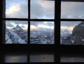
Paget Peak rises proudly above the Trans-Canada Highway at Wapta Lake. Its lower slopes have a trail leading from the road to a historic fire lookout with a nice view. Beyond the lookout, the trail turns into more of a scramble, and eventually reaches the summit of Paget Peak. It’s easy as far as Rocky Mountain scrambles go, but much tougher than your average day on the trail.
Beyond the Paget Lookout, the trail soon fades into the scree, but worn tracks and cairns may be visible. Keep plodding more or less straight up, looking for the path of least resistance. The slope is interrupted by a few rock bands, where ledges and blocks must be negotiated. You’ll likely find these sections more solid than the scree, but some large rocks will be loose, so use caution. You’ll cross over a false summit on the way to the true summit, where the pitch finally levels out. There are drop offs from the summit ridge and snow cornices may be present, but for the most part it’s easy walking on top. Return by the same route, but remember that routefinding can be trickier on the way down, so take it slow.
Sources: https://windsofjane.com/2020/07/15/paget-lookout-to-paget-peak-best-hike-in-yoho-national-park http://bobspirko.ca/Field/PagetPeak/PagetNorthRidge.html
Easy
The ascent involves simple glacier hiking and/or short, straightforward rock scrambles. Equivalent to Alpine F, F+

Little chance of being seen or helped in case of an accident.
9.3 km away
O'Hara Approach to the Summit of Mount Victoria
Moderate Alpine Climbing