6.5 km away
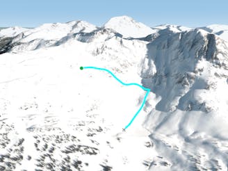
Ladies First

Steep, deep and few tracks, worth the bootpack access!
Severe Freeride Skiing
- Distance
- 821 m
- Ascent
- 76 m
- Descent
- 235 m
definitely no avalanche
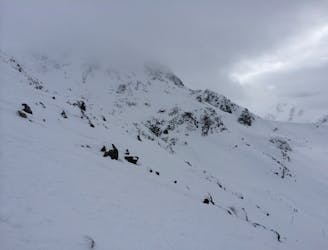
Freeride Skiing Extreme

This is a popular freeride skiing route which is generally considered to be extreme. It's extremely remote, it features high exposure (e3) and is typically done between January and March. From a low point of 1.3 km to the maximum altitude of 2.6 km, the route covers 7.8 km, 52 vertical metres of ascent and 1323 vertical metres of descent. You'll need skins, ice axe and glacier kit to complete it safely.
High alpine and trees
Extreme
Extreme skiing terrain above 45 degrees. These routes are reserved for experienced experts.

In case of a fall, death is highly likely.

In the high mountains or remote conditions, all individuals must be completely autonomous in every situation.
6.5 km away
Steep, deep and few tracks, worth the bootpack access!
Severe Freeride Skiing
6.5 km away

Steep chute that negotiates itself around several cliffs with a mandatory air at the bottom.
Severe Freeride Skiing
6.5 km away
A short but fun line which is good for getting a couple of fresh turns.
Severe Freeride Skiing
6.5 km away

A steep, corniced chute with a mandatory double air.
Extreme Freeride Skiing
6.5 km away

On the boundaries of the ski area on Blackcomb Glacier lies this steep pitch and often deep turns too with the right winds.
Difficult Freeride Skiing
6.5 km away

A long, thin straight-line chute with a sizeable cornice and a steep runout
Severe Freeride Skiing
6.5 km away

A fun steep chute where you can throw down some good powder turns
Severe Freeride Skiing
6.6 km away
Mellow pitch, with some fun little cliff to pop off.
Difficult Freeride Skiing
6.6 km away

One of the first places you can drop in off the high-traverse into Lakeside Bowl.
Severe Freeride Skiing
6.6 km away
The classic line through the center of wide-open Lakeside Bowl
Difficult Freeride Skiing

10 routes · Freeride Skiing