36 m away
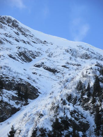
Pointe d'Angolon

Backcountry skiing with magnificent views for competent off-piste skiers.
Difficult Freeride Skiing
- Distance
- 2.8 km
- Ascent
- 126 m
- Descent
- 997 m
Little walk needed into a long line with steep first part.
Freeride Skiing Extreme

An easily accessed line. Just turn left on top of "Chamossiere" chairlift and hike until the top of "Chamossiere" summit for about 15 minutes. The entrance of the line is really steep and navigation is important as the left side has got a cliff. The line gets a lot of sun so make sure the snow conditions are good enough before heading in. Avalanche risk is pretty important on the highest part due to the steepness around here. The lower area is safer as not too steep but snow can be refrozen due to the more westerly aspect. It finishes on the red piste "L'eterlou" which leads back to Nyon ski area or "Les Gets" ski area if wanted.
Extreme
Extreme skiing terrain above 45 degrees. These routes are reserved for experienced experts.

In case of a fall, death is highly likely.
Little chance of being seen or helped in case of an accident.
36 m away
Backcountry skiing with magnificent views for competent off-piste skiers.
Difficult Freeride Skiing
141 m away

Under the chairlift with rocks and steepness on a west facing slope.
Extreme Freeride Skiing
1.5 km away

A long line below and then over a ridge with some steepness and a mix of snow conditions.
Extreme Freeride Skiing
1.5 km away

Little walk needed to enter a steep and sunny line.
Extreme Freeride Skiing
1.9 km away

Easily accessed descent from the highpoint of the Les Gets area
Difficult Freeride Skiing
4.3 km away

Magnificent and very steep couloir on the north side of Ressachaux.
Extreme Freeride Skiing
5 km away

Bag a summit and enjoy an enormous off-piste face with a variety of lines in close proximity to the resort.
Severe Freeride Skiing
5.4 km away

This steep couloir is a slightly easier descent than its neighbour.
Severe Freeride Skiing
5.8 km away

Lift accessed area classic with a free bus ride back to Morzine.
Moderate Freeride Skiing
6.3 km away

A legendary couloir known to be popular with the local ski patrol, for expert skiers only.
Severe Freeride Skiing
9 routes · Freeride Skiing · Ski Touring