302 m away
Cerf's line
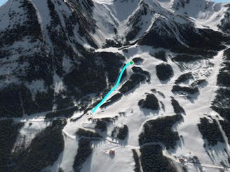
A nice shortcut below the chairlift "TS Fontaines, giving access back the to plateau of the "Crét beni".
Difficult Freeride Skiing
- Distance
- 584 m
- Ascent
- 1 m
- Descent
- 143 m
Long walk into a steep area including a really steep line into an isolated area.
Freeride Skiing Extreme

This is a really long access line with a walk for about 1 1/2 hours as you go straight up from "Fontaines" chairlift and walk into the gully, take a left below the ridge to reach the little summit. Then some arete skiing is needed to reach the start of the line where "Cret Beni's" area can be seen. The hiking part is steep as is the line itself into a gully close some trees. The line gets well protected from the sun so make sure weather conditions are good into this part of the mountain but also that there's enough snow before heading in due to the low altitude. Avalanche risk is important into this area due to the steepness around here, good navigation skills needed. The line finishes at the bottom of "Fontaines" chairlift which leads back to Cret Beni ski area.
Extreme
Extreme skiing terrain above 45 degrees. These routes are reserved for experienced experts.

As well as the slope itself, there are some obstacles (such as rock outcrops) which could aggravate injury.

In the high mountains or remote conditions, all individuals must be completely autonomous in every situation.
302 m away
A nice shortcut below the chairlift "TS Fontaines, giving access back the to plateau of the "Crét beni".
Difficult Freeride Skiing
453 m away

From top of "Fontaines" chairlift follow "Cerf's gully line" hike until the top of the gully in your right side for about 45 minutes, to the higher peak in front of you.
Extreme Freeride Skiing
985 m away

A nice line if there is decent snow on the skiers R of chairlift, where there are plenty of nice small trees.
Difficult Freeride Skiing
1 km away

A full exploring line with steepness some hiking and climbing skills needed.
Extreme Freeride Skiing
1.3 km away

A long hike access line until the summit where a really steep hike is present including a steep line into little part into an isolated area.
Extreme Freeride Skiing
1.5 km away

A really steep and engaged line area into a short line only for expert skiers.
Extreme Freeride Skiing
1.5 km away

Easy access line and steep line close the trees.
Extreme Freeride Skiing
1.5 km away

Steep line in some forest area for only autonomous skiers.
Extreme Freeride Skiing
1.6 km away

Expert line mixing hiking, steepness, trees and rocks.
Extreme Freeride Skiing
1.7 km away

A long access line into an isolated area with really steep skiing skills needed.
Extreme Freeride Skiing