918 m away
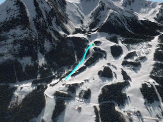
Mont de Grange West Face.

A half day line with a lot of hiking and some really good skiing skills required.
Extreme Freeride Skiing
- Distance
- 2 km
- Ascent
- 45 m
- Descent
- 733 m
A long hike access line until the summit where a really steep hike is present including a steep line into little part into an isolated area.
Freeride Skiing Extreme

This is a long access line from the top of "Fontaines" chairlift where a 1 1/2 hour hike is needed. The line is steep on the hiking part too and skins can make it much quicker. Turn left after the ridge on your left side, more or less follow "Cret beni steep line" access until the little summit. The line gets a lot of sun so make sure snow conditions are worthy before heading in. Avalanche risk is pretty important due the face exposure taking a lot of sun and making the area more unstable. Apart from a couple of steep parts the area feels pretty gentle in terms of gradient. The line finishes on the green piste "Pingouin" which leads back to Cret Beni ski area after a walk back by the forest to the main ski area.
Extreme
Extreme skiing terrain above 45 degrees. These routes are reserved for experienced experts.

As well as the slope itself, there are some obstacles (such as rock outcrops) which could aggravate injury.

In the high mountains or remote conditions, all individuals must be completely autonomous in every situation.
918 m away
A half day line with a lot of hiking and some really good skiing skills required.
Extreme Freeride Skiing
991 m away

A long access line into an isolated area with really steep skiing skills needed.
Extreme Freeride Skiing
1.1 km away

From top of "Fontaines" chairlift follow "Cerf's gully line" hike until the top of the gully in your right side for about 45 minutes, to the higher peak in front of you.
Extreme Freeride Skiing
1.3 km away

Long walk into a steep area including a really steep line into an isolated area.
Extreme Freeride Skiing
1.5 km away
A nice shortcut below the chairlift "TS Fontaines, giving access back the to plateau of the "Crét beni".
Difficult Freeride Skiing
1.5 km away

Expert line mixing hiking, steepness, trees and rocks.
Extreme Freeride Skiing
1.8 km away

A really steep and engaged line area into a short line only for expert skiers.
Extreme Freeride Skiing
1.9 km away

A full exploring line with steepness some hiking and climbing skills needed.
Extreme Freeride Skiing
1.9 km away

Easy access line and steep line close the trees.
Extreme Freeride Skiing
2.1 km away

A nice line if there is decent snow on the skiers R of chairlift, where there are plenty of nice small trees.
Difficult Freeride Skiing