519 m away
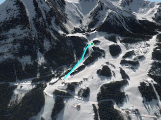
Hermine's forest line

Steep line in some forest area for only autonomous skiers.
Extreme Freeride Skiing
- Distance
- 1.4 km
- Ascent
- 37 m
- Descent
- 366 m
A full exploring line with steepness some hiking and climbing skills needed.
Freeride Skiing Extreme

A long full day expedition line by La Chapelle d'Abondance where you turn left at "Les Combes" ski lift into the gully hiking until the top of the Mont Grange peak "plateau", hike take a full day and need some good skills as steep terrain is present. Arete is the best option for the hike and skins make it much quicker, however below the summit good climbing skills are welcome due the rock terrain, steepness, avalanche risks. Line going to be on a long arete joining "Plagne to Plaine dranse line", line exposure is taking a lot of sun so make the weather conditions are good as the avalanche risks is really important there. Line is optional and some other run done if you want to void some steep part, "Plagne to Plaine dranse line" once join bring the expedition to green slope "Les Rubis".
Extreme
Extreme skiing terrain above 45 degrees. These routes are reserved for experienced experts.

In the high mountains or remote conditions, all individuals must be completely autonomous in every situation.
519 m away
Steep line in some forest area for only autonomous skiers.
Extreme Freeride Skiing
625 m away

Easy access line and steep line close the trees.
Extreme Freeride Skiing
678 m away

A really steep and engaged line area into a short line only for expert skiers.
Extreme Freeride Skiing
778 m away

From top of "Fontaines" chairlift follow "Cerf's gully line" hike until the top of the gully in your right side for about 45 minutes, to the higher peak in front of you.
Extreme Freeride Skiing
1 km away

Long walk into a steep area including a really steep line into an isolated area.
Extreme Freeride Skiing
1.1 km away

Expert line mixing hiking, steepness, trees and rocks.
Extreme Freeride Skiing
1.2 km away
A nice shortcut below the chairlift "TS Fontaines, giving access back the to plateau of the "Crét beni".
Difficult Freeride Skiing
1.7 km away

A long access line into an isolated area with really steep skiing skills needed.
Extreme Freeride Skiing
1.7 km away

A nice line if there is decent snow on the skiers R of chairlift, where there are plenty of nice small trees.
Difficult Freeride Skiing
1.8 km away

A half day line with a lot of hiking and some really good skiing skills required.
Extreme Freeride Skiing