6 km away
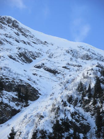
Ranfoilly Peak

Easily accessed descent from the highpoint of the Les Gets area
Difficult Freeride Skiing
- Distance
- 1.5 km
- Ascent
- 12 m
- Descent
- 377 m
A nice in-between-slopes lines with a steep entrance.
Freeride Skiing Difficult

A really easy access line where as we will turn before the red slope "Marmottes", entrance will be the steepest part bringing as well some risk of avalanches. Line is as her name said it into a north face, we will be into the middle of gully, what will make it more risky in term of avalanches. As soon as the entrance passed line will loose some steepness all along the way down, what will take out the avalanches risk down. Line is around 1700 meters what mean good snow cover can be found in this area, unless trees and a little river into the middle of the line there is no much more hazards in this part of the mountain. Entrance will required good skills then the line will be more gentle joining back the red slope "Marmottes" on the flat section getting back to the "Chéry Nord" chairlift. Bringing you up to the Mont Chéry or going to "Les Gets" village.
Difficult
Serious gradient of 30-38 degrees where a real risk of slipping exists.

As well as the slope itself, there are some obstacles (such as rock outcrops) which could aggravate injury.
Away from help but easily accessed.
6 km away
Easily accessed descent from the highpoint of the Les Gets area
Difficult Freeride Skiing
6.3 km away

Little walk needed to enter a steep and sunny line.
Extreme Freeride Skiing
6.3 km away

A long line below and then over a ridge with some steepness and a mix of snow conditions.
Extreme Freeride Skiing
7 km away

Under the chairlift with rocks and steepness on a west facing slope.
Extreme Freeride Skiing
7.2 km away

Little walk needed into a long line with steep first part.
Extreme Freeride Skiing
7.2 km away

Backcountry skiing with magnificent views for competent off-piste skiers.
Difficult Freeride Skiing
7.8 km away

Magnificent and very steep couloir on the north side of Ressachaux.
Extreme Freeride Skiing
9.7 km away

Bag a summit and enjoy an enormous off-piste face with a variety of lines in close proximity to the resort.
Severe Freeride Skiing
9.8 km away

Easy and gentle line close the trees.
Easy Freeride Skiing
9 routes · Freeride Skiing · Ski Touring