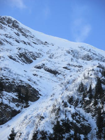
3.1 km away
TC Chéry Nord's line

A nice in-between-slopes lines with a steep entrance.
Difficult Freeride Skiing
- Distance
- 752 m
- Ascent
- 0 m
- Descent
- 248 m
Nice daytrip to ski the north face of p'ointe d'Uble and the Southside of Pointe de Chalune
Freeride Skiing Severe

This is a popular freeride skiing route which is generally considered to be severe. It's remote, it features medium exposure (e2) and is typically done between February and March. From a low point of 1.1 km to the maximum altitude of 2.1 km, the route covers 13 km, 1554 vertical metres of ascent and 1550 vertical metres of descent. You'll need skins to complete it safely.


A great day with Berio ski, see this route in the last part of the Episode: https://www.youtube.com/watch?v=8SWjfQj2wRE&t=641s
Severe
Steep skiing at 38-45 degrees. This requires very good technique and the risk of falling has serious consequences.

As well as the slope itself, there are some obstacles (such as rock outcrops) which could aggravate injury.
Away from help but easily accessed.
3.1 km away
A nice in-between-slopes lines with a steep entrance.
Difficult Freeride Skiing
7.4 km away

Easily accessed descent from the highpoint of the Les Gets area
Difficult Freeride Skiing
8.5 km away

Little walk needed to enter a steep and sunny line.
Extreme Freeride Skiing
8.6 km away

A long line below and then over a ridge with some steepness and a mix of snow conditions.
Extreme Freeride Skiing
8.9 km away

Under the chairlift with rocks and steepness on a west facing slope.
Extreme Freeride Skiing
9 km away

Backcountry skiing with magnificent views for competent off-piste skiers.
Difficult Freeride Skiing
9 km away

Little walk needed into a long line with steep first part.
Extreme Freeride Skiing
9 routes · Freeride Skiing · Ski Touring