185 m away
Les Rossets

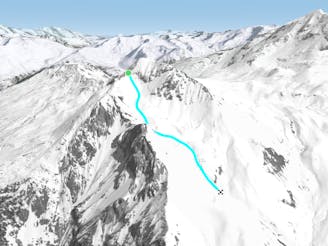
A fairly short, but enjoyable series of bowls and funnels leading through the steep ground on the east face of the Roche de Mio
Difficult Freeride Skiing
- Distance
- 985 m
- Ascent
- 3 m
- Descent
- 434 m
A magnificent wild open valley with a tricky exit, ending in an isolated village
Freeride Skiing Difficult

A fabulous off-piste adventure, with reasonable skiing but very careful route-finding required. A good snowpack is necessary to avoid bare south-facing slopes at the end. The top sections is prone to windslab. The exit follows a narrow track with sheer drops, and is the only way out through cliff barriers to the valley bottom. From the top of La Mio black piste, branch left where the piste turns right, and follow the ridge for about 200m. Move slightly down the left-hand slope until the slope below eases a little and it is possible to cut back sharply left and traverse down across a steep slope into the main bowl. Follow the floor of the bowl, moving to the left side where it narrows to a real valley, and continue all the way above the stream until near the final steepening. Keep your height above the stream, aiming for a small col directly ahead, on the left of the valley as it bears right and drops steeply to the main valley. Pop over the col and into a small bowl which funnels down to a narrow outlet. Pick up the track which cuts out right from the end of the tiny valley, and makes a sharp zig-zag back left across a very steep slope, and down to the tiny hamlet of Les Bois.
Difficult
Serious gradient of 30-38 degrees where a real risk of slipping exists.

Little chance of being seen or helped in case of an accident.
185 m away
A fairly short, but enjoyable series of bowls and funnels leading through the steep ground on the east face of the Roche de Mio
Difficult Freeride Skiing
2.2 km away

An equally fine companion route to the Couloir de Pramain
Difficult Freeride Skiing
2.7 km away

The easiest of the classics on the true north face.
Severe Freeride Skiing
2.7 km away

A classic route down the north face, one of the less risky routes
Moderate Freeride Skiing
2.7 km away

A beautiful, varied line down wild open slopes
Difficult Freeride Skiing
3.2 km away

Fantastic but serious big mountain line on a majestic, wild north face
Severe Freeride Skiing
8.2 km away
A hike to some great views followed by a flowing descent down a west facing bowl
Moderate Freeride Skiing
8.2 km away
A wild, steep line that needs stable snow conditions and finishes outside the lift served area
Severe Freeride Skiing
8.3 km away

A steep rarely skied line from the top of the Aiguille Grive
Severe Freeride Skiing
8.7 km away

The easier way down the Aiguille Grive
Difficult Freeride Skiing
25 routes · Freeride Skiing
6 routes · Freeride Skiing

15 routes · Freeride Skiing · Ski Touring