6.3 km away
Berni Couloir

One of the most aesthetic couloirs on this side of the mountain
Severe Ski Touring
- Distance
- 2.9 km
- Ascent
- 55 m
- Descent
- 880 m
A true ski mountaineering line
Ski Touring Difficult

This line will take you to the top of Testa Grigia, follow the same line to reach Colle Pinter then you will have to go left pointing the north slope to reach the top of Monte Pinter. From here you will have to reach bivacco Lateltin and the climb the SE ridge towards the top of Testa Grigia. You can ski down the same line you climbed, but be aware that this is a serious steep terrain, where every mistake could result in serious injuries! In order to climb the ridge you could need a rope and crampons, ice axe and harness. On your way down you can ski the line that descends from Colle Pinter or you can directly go back towards Champoluc.
Difficult
Serious gradient of 30-38 degrees where a real risk of slipping exists.

As well as the slope itself, there are some obstacles (such as rock outcrops) which could aggravate injury.

In the high mountains or remote conditions, all individuals must be completely autonomous in every situation.
6.3 km away
One of the most aesthetic couloirs on this side of the mountain
Severe Ski Touring
8.8 km away
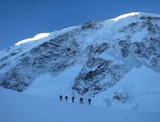
Day 3: Traverse of Passo del Naso of Lyskamm and summit of Pyramid Vincent, beginning at Rifugio Quintino Sella and ending at Capanna Gnifetti.
Severe Ski Touring
8.8 km away
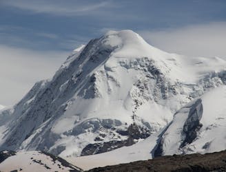
Venture up Switzerland’s famously treacherous Liskamm 4000er, affectionately nicknamed the “people eater”.
Severe Ski Touring

5 routes · Ski Touring

16 routes · Ski Touring