4.5 km away
Lago di Pilato from Foce
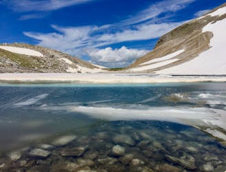
A gorgeous, yet moderately-strenuous, climb to the magical, mysterious, and only natural lake in Le Marche.
Difficult Hiking
- Distance
- 12 km
- Ascent
- 1 km
- Descent
- 1 km
Itinerario n. 36 del libro "I 50 sentieri più belli delle Marche"
Hiking Easy

This is a popular hiking route which is generally considered to be easy. It's remote, it features low exposure and is typically done all year round. From a low point of 1 km to the maximum altitude of 1.1 km, the route covers 4.2 km, 153 vertical metres of ascent and 154 vertical metres of descent.
Partenza da Colle di Montegallo per un anello poco impegnativo ai piedi del Monte Vettore.
Easy
Walking along a well-kept trail that’s mostly flat. No obstacles are present.

The path is on completely flat land and potential injury is limited to falling over.

Away from help but easily accessed.
4.5 km away
A gorgeous, yet moderately-strenuous, climb to the magical, mysterious, and only natural lake in Le Marche.
Difficult Hiking
7.1 km away
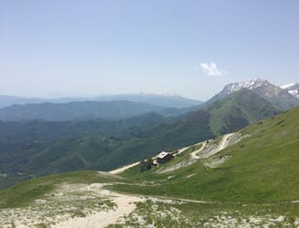
A magnificent high alpine ridge line hike to two incredible vantage points.
Moderate Hiking