4.6 km away
Cima Vallelunga and Monte Sibilla Loop
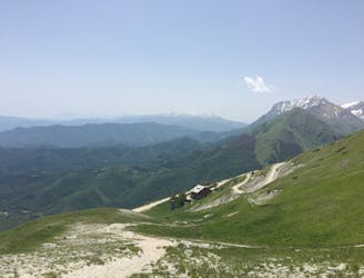
A magnificent high alpine ridge line hike to two incredible vantage points.
Moderate Hiking
- Distance
- 14 km
- Ascent
- 766 m
- Descent
- 766 m
ZITTU E CAMMINA E MAGNECE LO PA'!
Also in Ascoli Piceno, Italy
Hiking Severe

This is a popular hiking route which is generally considered to be severe. It's remote, it features high exposure and is typically done between May and September. From a low point of 1 km to the maximum altitude of 2.5 km, the route covers 32 km, 2454 vertical metres of ascent and 2586 vertical metres of descent.
seconda tappa del trekking che prende la maggiorparte dei punti di interesse delle montagne del Parco Nazionale dei Monti Sibillini. questa seconda tappa può essere prolungata di un giorno bivaccando sulla grotta sotto il Pizzo del Diavolo, passando per il Lago di Pilato.
Severe
Hiking challenging trails where simple scrambling, with the occasional use of the hands, is a distinct possibility. The trails are often filled with all manner of obstacles both small and large, and the hills are very steep. Obstacles and challenges are often unexpected and can be unpredictable.

Some trail sections have exposed ledges or steep ascents/descents where falling could cause serious injury.

Away from help but easily accessed.
4.6 km away
A magnificent high alpine ridge line hike to two incredible vantage points.
Moderate Hiking
5 km away
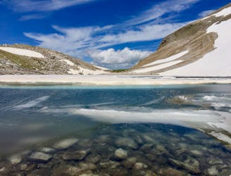
A gorgeous, yet moderately-strenuous, climb to the magical, mysterious, and only natural lake in Le Marche.
Difficult Hiking