10 m away
Mine Shaft

The steepest and narrowest of the Saddle gullies
Difficult Freeride Skiing
- Distance
- 914 m
- Ascent
- 0 m
- Descent
- 375 m
Boot pack up to the summit
Freeride Skiing Difficult

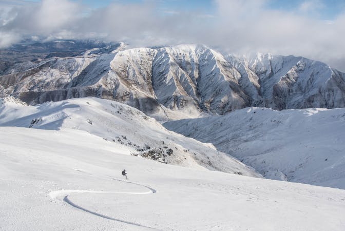
This is a popular freeride skiing route which is generally considered to be difficult. It's an unknown remoteness, it features medium exposure (e2) and is typically done between July and September. From a low point of 2 km to the maximum altitude of 2.1 km, the route covers 655 m, 99 vertical metres of ascent and 12 vertical metres of descent. It's graded 2.2 and Labande grade 2.
There is a gate on looker's right of the saddle chairlift this is the start point for the hike to the summit. On a busy day there will be a good boot pack here.
Allow 30 minutes for the climb.
Difficult
Serious gradient of 30-38 degrees where a real risk of slipping exists.

As well as the slope itself, there are some obstacles (such as rock outcrops) which could aggravate injury.
10 m away
The steepest and narrowest of the Saddle gullies
Difficult Freeride Skiing
84 m away

A huge, wide open area right in the middle of the saddle
Difficult Freeride Skiing
267 m away

A short but fun gully
Difficult Freeride Skiing
317 m away

Not a run, but a series of cliffs that are a freerider's idea of heaven.
Severe Freeride Skiing
407 m away

Open sidecountry above the Motutapu Chutes
Easy Freeride Skiing
413 m away

The most playful gully in the saddle
Difficult Freeride Skiing
417 m away

A wide open bowl that funnels into steep terrain
Severe Freeride Skiing
474 m away

The infamous Motutapu Chutes - New Zealand sidecountry at its best
Severe Freeride Skiing
490 m away

A steeper walled pipe that collects a lot of snow
Difficult Freeride Skiing
590 m away

One of many gullies that make up the saddle, this is a big wide one that collects snow.
Difficult Freeride Skiing
10 routes · Freeride Skiing · Ski Touring