152 m away
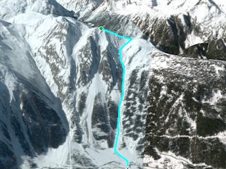
Croix de Fer Couloir

Steep, very serious and sustained skiing leads you to the village of Trient.
Severe Freeride Skiing
- Distance
- 1.8 km
- Ascent
- 0 m
- Descent
- 868 m
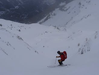
A real adventure linking bowls and steep faces all the way to the town of Châtelard.
Freeride Skiing Difficult

A real adventure taking you well away from the lift system, linking bowls and steep faces all the way to the town of Châtelard. Hike from the Tête de Balme to L'Arolette summit. Traverse high round to the col before side stepping up onto the west face of the Pointe du Van. Turn left to ski the weakness down the face leading into the forest below. The route links open meadows with tight forested terrain before arriving at a reservoir. From here start traversing right on a hiking trail back to Châtelard. You do not finish at the lifts and will need to get the bus/train to rejoin the resort. Beware this area sees some big avalanches and experienced skiers have been caught out despite the apparently relatively innocuous terrain.
Difficult
Serious gradient of 30-38 degrees where a real risk of slipping exists.

As well as the slope itself, there are some obstacles (such as rock outcrops) which could aggravate injury.

Little chance of being seen or helped in case of an accident.
152 m away
Steep, very serious and sustained skiing leads you to the village of Trient.
Severe Freeride Skiing
318 m away

A wild, steep and serious descent for experts only.
Extreme Freeride Skiing
369 m away
A serious but fantastic route with a combination of fast, flowing skiing and some steep narrow sections.
Severe Freeride Skiing
720 m away
Giving 600 meters of fantastic skiing, this is worth the hike.
Severe Freeride Skiing
1.2 km away

A wide open face offering good skiing far from the crowds.
Difficult Freeride Skiing
1.2 km away

This run offers great off piste skiing in relatively gentle undulating terrain.
Difficult Freeride Skiing
1.4 km away

A real treat with easy access, varied terrain and descent options.
Difficult Freeride Skiing
1.9 km away

A series of gullies offering great skiing with a lot of variety and options, all easily accessed from a lift.
Difficult Freeride Skiing
3.3 km away
Long consistent, but serious couloirs offer amazing skiing.
Severe Freeride Skiing
3.3 km away

A real adventure as you traverse and ski fantastic terrain all the way to the valley floor.
Difficult Freeride Skiing

10 routes · Freeride Skiing
10 routes · Freeride Skiing