54 m away
Trient via Les Tornays
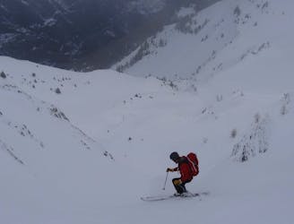
A serious but fantastic route with a combination of fast, flowing skiing and some steep narrow sections.
Severe Freeride Skiing
- Distance
- 2.2 km
- Ascent
- 3 m
- Descent
- 912 m
A wild, steep and serious descent for experts only.
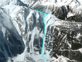
Freeride Skiing Extreme

The Van couloirs are all steep, serious and avalanche prone - skiing them requires a great deal of experience. This line frequently avalanches in its entirety so, as well as making sure you don't set it off, you'll need to know that it hasn't already gone as otherwise you'll be skiing a lot of unpleasant debris at the bottom. In the right conditions this offers an incredible descent with sections of 50 degree skiing. Hike from the Tête de Balme chairlift to L'Arolette summit. Traverse high round to the col before side stepping up onto the west face of the Pointe du Van. Contour round to the N face and enter the couloir from the shoulder. The initial wide slopes narrow through a short technical rock band. Ski the remainder of the couloir which is tight, narrow and serious. The slopes open in the bottom allowing fast flowing freeride! Traverse back to Trient via the Ski du Fond track.
Extreme
Extreme skiing terrain above 45 degrees. These routes are reserved for experienced experts.

As well as the slope itself, there are some obstacles (such as rock outcrops) which could aggravate injury.

In the high mountains or remote conditions, all individuals must be completely autonomous in every situation.
54 m away
A serious but fantastic route with a combination of fast, flowing skiing and some steep narrow sections.
Severe Freeride Skiing
166 m away

Steep, very serious and sustained skiing leads you to the village of Trient.
Severe Freeride Skiing
318 m away

A real adventure linking bowls and steep faces all the way to the town of Châtelard.
Difficult Freeride Skiing
991 m away
Giving 600 meters of fantastic skiing, this is worth the hike.
Severe Freeride Skiing
1.5 km away

This run offers great off piste skiing in relatively gentle undulating terrain.
Difficult Freeride Skiing
1.5 km away

A wide open face offering good skiing far from the crowds.
Difficult Freeride Skiing
1.7 km away

A real treat with easy access, varied terrain and descent options.
Difficult Freeride Skiing
2.2 km away

A series of gullies offering great skiing with a lot of variety and options, all easily accessed from a lift.
Difficult Freeride Skiing
3.5 km away
Long consistent, but serious couloirs offer amazing skiing.
Severe Freeride Skiing
3.5 km away

A real adventure as you traverse and ski fantastic terrain all the way to the valley floor.
Difficult Freeride Skiing

10 routes · Freeride Skiing
10 routes · Freeride Skiing