176 m away
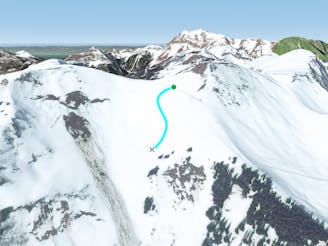
Morclan's line

An easy accessed line but condition dependent, requiring a good technical level.
Severe Freeride Skiing
- Distance
- 1.4 km
- Ascent
- 7 m
- Descent
- 532 m
A long line which has both steepness and avalanche risks.
Freeride Skiing Severe

Another easily accessed line, reached by turning left from the top of Morclan's chairlift. The entrance is the steepest part, where a few trees will be present, and avalanche risk is quite often present too due to the line facing west. Wet snow can be often found and the bottom can have a thin base too. The bottom of the line also has one unusual hazard to be aware of - fences separating various bits of land. After a long traverse the line finishes at the bottom of the "Conche" chairlift, or the red slope "La Combe" going to the village.
Severe
Steep skiing at 38-45 degrees. This requires very good technique and the risk of falling has serious consequences.

As well as the slope itself, there are some obstacles (such as rock outcrops) which could aggravate injury.

Little chance of being seen or helped in case of an accident.
176 m away
An easy accessed line but condition dependent, requiring a good technical level.
Severe Freeride Skiing
235 m away

An easy navigation line with a bit of steepness and trees.
Difficult Freeride Skiing
249 m away

A long line close to the red slope "Chermillon red", this is a good place to go with fresh snow.
Severe Freeride Skiing
267 m away

A fully panoramic line with a long traverse and some steepness which requires good navigational skills.
Extreme Freeride Skiing
295 m away

A very steep line with optional cliffs which is often tracked out early due to its easy access
Extreme Freeride Skiing
579 m away

A nice bit of skiing close to the slopes with some good steepness and a bit of tree skiing.
Severe Freeride Skiing
619 m away
A small, fairly steep shortcut from "Foliere" piste joining back the black piste "Ombrieux".
Difficult Freeride Skiing
984 m away

A small shortcut to go to when fresh snowfall arrives.
Moderate Freeride Skiing
992 m away

A quite flat crossing between trees where keeping your speed is the key of this line.
Easy Freeride Skiing
1 km away

An easy line close the slopes where few nice turns can be done between trees and the lower river section.
Moderate Freeride Skiing