35 m away
Chermillon's line

A long line close to the red slope "Chermillon red", this is a good place to go with fresh snow.
Severe Freeride Skiing
- Distance
- 864 m
- Ascent
- 4 m
- Descent
- 237 m
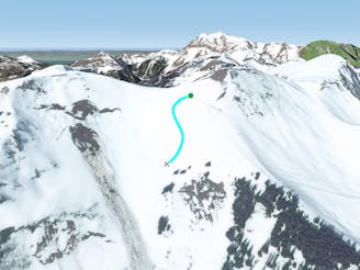
A fully panoramic line with a long traverse and some steepness which requires good navigational skills.
Freeride Skiing Extreme

From the top of the Morclan's chairlift, take the red slope "Chermillon red" but instead of going to the slope continue straight following the arête; navigation will be helped by some patches of trees all around our line, we will have to stay on the left on the patches what will guide us. Steepness will close these 2 patches of trees and this is real steepness, we are about 50 degrees what make the area really dangerous in term of riding skills and avalanches. East exposure face will make it more unstable as the sun is often present into this part, what can make the face as well unstable at the end of the season as well. Second patch of trees will be the longer steep part of the line, but not the steepest, won't recommend to go there in case of low visibility as getting lost mean the left part will behere for you and cornice crash might injured you badly. Once the second steep part passed, access to the blue slope "Panoramique (Chaux Longe)" will be there for you giving you access to the "Pré la Vieille" and "TK de Chermeu" ski lifts.
Extreme
Extreme skiing terrain above 45 degrees. These routes are reserved for experienced experts.

As well as the slope itself, there are some obstacles (such as rock outcrops) which could aggravate injury.

In the high mountains or remote conditions, all individuals must be completely autonomous in every situation.
35 m away
A long line close to the red slope "Chermillon red", this is a good place to go with fresh snow.
Severe Freeride Skiing
42 m away

An easy navigation line with a bit of steepness and trees.
Difficult Freeride Skiing
101 m away

An easy accessed line but condition dependent, requiring a good technical level.
Severe Freeride Skiing
119 m away

A very steep line with optional cliffs which is often tracked out early due to its easy access
Extreme Freeride Skiing
267 m away

A long line which has both steepness and avalanche risks.
Severe Freeride Skiing
464 m away

A nice bit of skiing close to the slopes with some good steepness and a bit of tree skiing.
Severe Freeride Skiing
495 m away
A small, fairly steep shortcut from "Foliere" piste joining back the black piste "Ombrieux".
Difficult Freeride Skiing
766 m away

A quite flat crossing between trees where keeping your speed is the key of this line.
Easy Freeride Skiing
818 m away

A small shortcut to go to when fresh snowfall arrives.
Moderate Freeride Skiing
1 km away

An easy line close the slopes where few nice turns can be done between trees and the lower river section.
Moderate Freeride Skiing