379 m away
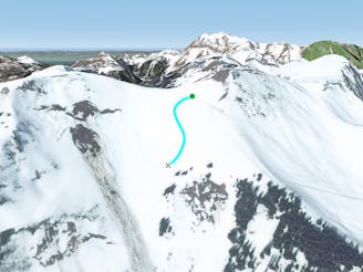
Tour de Don's sunny line.

A steep sunny line
Severe Freeride Skiing
- Distance
- 1 km
- Ascent
- 1 m
- Descent
- 272 m
Really steep and high level line in a total autonomous area.
Freeride Skiing Extreme

This is an easily accessed line as turn left into "Tronchey's" chairlift and hike for about 20 minutes until the top of Tour de Don summit. The line really steep and mistake will kill you, only expert skiers should go there and good steep skiing skills are more than needed. The line gets well protected from the sun due to the North face exposure, a good weather checked is needed before heading in as icy base can make it a nightmare. Avalanche risk is really high due to the steepness of the gully, lower part is less exposed and trees are here help to keep it more stable. The line finishes by following "Tour de Don's north face" line which leads back to the top of ski lift "Fignard" going to Torgon's village
Extreme
Extreme skiing terrain above 45 degrees. These routes are reserved for experienced experts.

In case of a fall, the skier faces certain death.
In the high mountains or remote conditions, all individuals must be completely autonomous in every situation.
379 m away
A steep sunny line
Severe Freeride Skiing
417 m away

High steepness line only for expert skiers into a totally autonomous mountain area.
Extreme Freeride Skiing
420 m away

Easy access and steep line close the trees.
Severe Freeride Skiing
443 m away

A steep line with a really difficult entrance where high skiing skills are required.
Extreme Freeride Skiing
988 m away

A classic Barbossine line in this part of the mountain where good skills are needed.
Severe Freeride Skiing
1 km away

A long traverse leading to nice open slopes, not too steep.
Moderate Freeride Skiing
1.3 km away

Small hike needed, followed by a steep entrance getting less steep into the lower section.
Extreme Freeride Skiing
1.4 km away

A nice bit of skiing close to the slopes with some good steepness and a bit of tree skiing.
Severe Freeride Skiing
1.4 km away
A small, fairly steep shortcut from "Foliere" piste joining back the black piste "Ombrieux".
Difficult Freeride Skiing
1.5 km away

A wild line joining back to the Petit Chatel area to the bottom of the ski lift into a line crossing private filed and roads.
Easy Freeride Skiing