6 m away
Tour de don's north face

High steepness line only for expert skiers into a totally autonomous mountain area.
Extreme Freeride Skiing
- Distance
- 3.1 km
- Ascent
- 113 m
- Descent
- 673 m
Easy access and steep line close the trees.
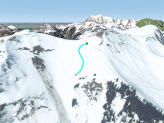
Freeride Skiing Severe

This is an easily accessed line turning left on top of "Tronchey's" chairlift, no any hike is required. The line has got some steepness and navigation mistakes can bring you into a steeper area, best advice is to keep into the right side of the chairlift for the 1st section. Again in this area the line is well protected from the sun so make sure the snow conditions and weather windows are good before heading in. Avalanche risk is pretty important due to the steepness, even if trees help to keep more stable the face around here. The line is guided by a big empty patch of trees and finishes on the blue piste "Lac Léman (Torgon)" which leads back to the same chairlift.
Severe
Steep skiing at 38-45 degrees. This requires very good technique and the risk of falling has serious consequences.

As well as the slope itself, there are some obstacles (such as rock outcrops) which could aggravate injury.
Away from help but easily accessed.
6 m away
High steepness line only for expert skiers into a totally autonomous mountain area.
Extreme Freeride Skiing
29 m away

A steep line with a really difficult entrance where high skiing skills are required.
Extreme Freeride Skiing
420 m away

Really steep and high level line in a total autonomous area.
Extreme Freeride Skiing
458 m away

A steep sunny line
Severe Freeride Skiing
654 m away

A classic Barbossine line in this part of the mountain where good skills are needed.
Severe Freeride Skiing
694 m away

A long traverse leading to nice open slopes, not too steep.
Moderate Freeride Skiing
898 m away

Small hike needed, followed by a steep entrance getting less steep into the lower section.
Extreme Freeride Skiing
1.3 km away

A wild line joining back to the Petit Chatel area to the bottom of the ski lift into a line crossing private filed and roads.
Easy Freeride Skiing
1.7 km away

A nice bit of skiing close to the slopes with some good steepness and a bit of tree skiing.
Severe Freeride Skiing
1.7 km away
A small, fairly steep shortcut from "Foliere" piste joining back the black piste "Ombrieux".
Difficult Freeride Skiing