140 m away
Abercastle to Goodwick
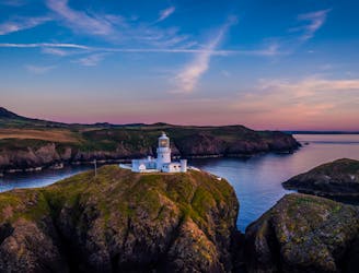
Pembrokeshire Coast Path
Difficult Hiking
- Distance
- 25 km
- Ascent
- 913 m
- Descent
- 902 m
Pembrokeshire Coast Path
Hiking Difficult

This is a popular hiking route which is generally considered to be difficult. It's remote, it features high exposure and is typically done between March and October. From a low point of 3 m to the maximum altitude of 110 m, the route covers 22 km, 724 vertical metres of ascent and 726 vertical metres of descent.
Walk including a pub, the Blue Lagoon and finish at a beautiful beach.
Difficult
Hiking trails where obstacles such as rocks or roots are prevalent. Some obstacles can require care to step over or around. At times, the trail can be worn and eroded. The grade of the trail is generally quite steep, and can often lead to strenuous hiking.

Some trail sections have exposed ledges or steep ascents/descents where falling could cause serious injury.

Away from help but easily accessed.
140 m away
Pembrokeshire Coast Path
Difficult Hiking