4.3 km away
The Devil's Pulpit and Finnich Glen
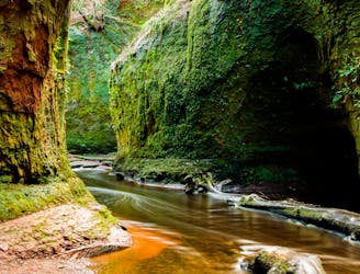
A short but famous stroll to a historical landmark
Moderate Hiking
- Distance
- 607 m
- Ascent
- 18 m
- Descent
- 18 m
Follow Rob Roy Way through forest plantation toward the tourist haven of Aberfoyle, with interesting sights en route like an old iron aqueduct and a glimpse of Ben Lomond in the distance.
Hiking Easy

This is a popular hiking route which is generally considered to be easy. It's an unknown remoteness, it features unknown exposure and is typically done in an unknown time of year. From a low point of 19 m to the maximum altitude of 215 m, the route covers 18 km, 321 vertical metres of ascent and 362 vertical metres of descent.
Easy
Walking along a well-kept trail that’s mostly flat. No obstacles are present.
4.3 km away
A short but famous stroll to a historical landmark
Moderate Hiking
6.4 km away
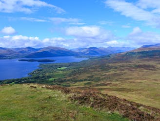
One of the most popular day hikes from Glasgow provides fabulous views over Loch Lomond
Difficult Hiking