7 m away
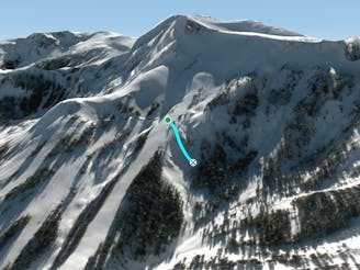
Waterfall Ridge

Steep exposed ridge with rocky features
Difficult Freeride Skiing
- Distance
- 151 m
- Ascent
- 0 m
- Descent
- 75 m
A zone with a few medium cliffs with better than average takeoffs
Freeride Skiing Difficult

This is a popular freeride skiing route which is generally considered to be difficult. It's remote, it features medium exposure (e2) and is typically done between November and April. From a low point of 2.5 km to the maximum altitude of 2.7 km, the route covers 296 m, 0 vertical metres of ascent and 113 vertical metres of descent. It's graded 3.2 and Labande grade 4.
A zone with a few medium cliffs with better than average takeoffs skier's left of Dick's Drop
Difficult
Serious gradient of 30-38 degrees where a real risk of slipping exists.

As well as the slope itself, there are some obstacles (such as rock outcrops) which could aggravate injury.
Away from help but easily accessed.
7 m away
Steep exposed ridge with rocky features
Difficult Freeride Skiing
88 m away
A narrow chute that usually is a straightline
Difficult Freeride Skiing
150 m away

Steep sunny zone with some fun obstacles
Difficult Freeride Skiing
358 m away

Wide open bowl with small to medium cliffs scattered throughout.
Difficult Freeride Skiing
422 m away

Incredibly steep corniced slope great for steep turns and littered with small cliffs
Severe Freeride Skiing
512 m away

Extremely narrow and steep chute that usually requires a straightline
Severe Freeride Skiing
529 m away

A narrow chute shaped like a heart surrounded by large volcanic walls that funnel into a large cliff.
Extreme Freeride Skiing
535 m away

A ‘U’ shaped wide chute just to the left of Heart Chute with incredible steep left wall.
Difficult Freeride Skiing
667 m away

Cliff and chute zone at the bottom of the Lower Cirque
Difficult Freeride Skiing
773 m away

Series of chutes located in Wagon Wheel Bowl off of Chair 6
Difficult Freeride Skiing

7 routes · Freeride Skiing
8 routes · Freeride Skiing