702 m away
Fulstone Canyon

A massive, rocky zone off the backside of the resort
Moderate Freeride Skiing
- Distance
- 647 m
- Ascent
- 0 m
- Descent
- 285 m
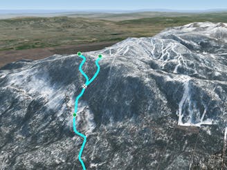
Trail that leads from Dipper to Skyline Trail
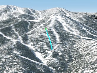
Freeride Skiing Easy

This is a popular freeride skiing route which is generally considered to be easy. It's not remote, it features low exposure (e1) and is typically done between December and April. From a low point of 3 km to the maximum altitude of 3 km, the route covers 262 m, 0 vertical metres of ascent and 21 vertical metres of descent.
Allows you to access Milky Way Bowl, Milky Way, Killebrew Gates A-C, and Mott Canyon Gates 1-4 directly from Dipper Express.
Easy
Wide gentle slopes at around 20 degrees or less.

Exposure is limited to that of the slope itself. Getting hurt is still likely if the slope is steep and/or the snow is hard.
Close to help in case of emergency.
702 m away
A massive, rocky zone off the backside of the resort
Moderate Freeride Skiing
1.8 km away
A big, wide swatch of sidecountry that's high-risk, high-reward
Moderate Freeride Skiing
2.4 km away
A wide expanse of glades below Nevada Trail
Moderate Freeride Skiing
8 routes · Freeride Skiing