1.4 km away
Sidehorn Trees

Long, powder-filled Aspen tree lines
Moderate Freeride Skiing
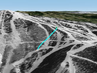
- Distance
- 807 m
- Ascent
- 0 m
- Descent
- 289 m
Skinny line that goes through a massive cliff face
Freeride Skiing Extreme

The Fish Creek area is a legendary side country canyon parallel to Steamboat Resort. It's home to some of the most accessible extreme terrain in all of Colorado! Zone -0.5 is an insane part of Fish Creek that is only accessible by either taking Zone 0 Alternative, or one of the Upper Zone -1 chutes. The one line in Zone -0.5 is known as "Cliff Chute" and is seldom skiable. Though if you do catch it on a good year, you'll find a ultra steep, but enjoyable line. Eventually, you'll merge onto the Perimeter trail which will take you to the bottom of the canyon where you must skin/hike out. Note on some years, you may be required to rappel down certain sections.
Extreme
Extreme skiing terrain above 45 degrees. These routes are reserved for experienced experts.

In case of a fall, death is highly likely.
Little chance of being seen or helped in case of an accident.
1.4 km away
Long, powder-filled Aspen tree lines
Moderate Freeride Skiing
2.5 km away

Tree chutes
Difficult Freeride Skiing
2.8 km away

A short open powder stash with pitch and glades
Moderate Freeride Skiing
2.8 km away

Tree chutes and powder meadows in Weasel Trees.
Moderate Freeride Skiing
2.9 km away

Powder meadows and long tree glades
Moderate Freeride Skiing
3 km away

Tree chutes and powder meadows in upper Weasel Trees.
Moderate Freeride Skiing
3.4 km away

Steep, technical tree Lines and rock drops
Moderate Freeride Skiing
3.5 km away

Tight, technical tree chutes and rock drops
Moderate Freeride Skiing
3.7 km away
Fall-line through Three O'Clock and Two O'Clock to High Noon
Moderate Freeride Skiing
3.9 km away

Tight, technical tree lines
Moderate Freeride Skiing