11 m away
Body Bag

A steep, gnarly run that ends in a mandatory 15 foot cliff band.
Extreme Freeride Skiing
- Distance
- 203 m
- Ascent
- 0 m
- Descent
- 125 m
Steep chutes that end in large cliffs at the bottom of the North Face.
Freeride Skiing Extreme

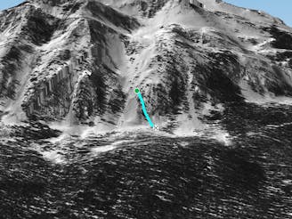
The Dead End Chutes are another classic Crested Butte area where you really need know where you're going. It consists of steep terrain that ends in large cliffs ranging from 15 to 50 feet. There are some sneaky ways through on high snow years, but be prepared for your feet to leave the ground. Access Dead End Chutes from the Rock N Roll Glades. When you get to a large orange sign Cliff Area sign, slow down and gather yourself. You are above Dead End Chutes. If you have a change of heart and want to bail, traverse right to the Leaning Tree Chute and Phoenix Last Steep. After a few mellow turns, you get into the meat of the cliffs.
Extreme
Extreme skiing terrain above 45 degrees. These routes are reserved for experienced experts.

Little chance of being seen or helped in case of an accident.
11 m away
A steep, gnarly run that ends in a mandatory 15 foot cliff band.
Extreme Freeride Skiing
66 m away
Leaning Tree Chute is an awesome, steep chute on the skier's right side of Dead End Chutes.
Severe Freeride Skiing
135 m away

A fun tree run littered with small cliff drops.
Severe Freeride Skiing
158 m away

A long shaded chute in the in the Staircase section of the North Face.
Severe Freeride Skiing
183 m away

A rocky cliff section near the bottom of the Staircase area.
Extreme Freeride Skiing
221 m away
A steep tree run containing cliffs and rocks near the Staircase section of the North Face.
Extreme Freeride Skiing
222 m away

A thick tree run through the steep trees that separate Slot Rocks and Sock it to Me Ridge.
Severe Freeride Skiing
244 m away

Steep but playful gladed terrain above the Staircase section of North Face.
Difficult Freeride Skiing
246 m away

Steep tree chutes with larger cliffs and lines
Extreme Freeride Skiing
276 m away

Big Hourglass is a permanently closed area on the skier's left side of lower Third Bowl sometimes used as freeride competition venue.
Extreme Freeride Skiing
80 routes · Freeride Skiing